Building lasting connections—with nature and each other
This summer Capitol Land Trust is making thoughtful improvements at Bayshore Preserve to make it easier and more enjoyable for people to connect with nature. These upgrades will enhance safety, expand accessibility, and support outdoor learning and recreation for years to come.
Since being conserved in 2014, Bayshore has become one of our most visited preserves—and this project builds on years of successful restoration and wonderful shared experiences with members of our local communities. We’re continuing that legacy by making the preserve more welcoming and functional for more people, while protecting the natural beauty and ecological health of the land.
Construction will begin on July 7, 2025, and will continue through October 2025 (weather dependent).
On this page, you’ll find:
- The latest updates and highlights on construction progress
- Map and visitor information
- What we’re building
- Ways to stay connected
- FAQ
Current Status (Updated Thursday, October 9, 2025)
-

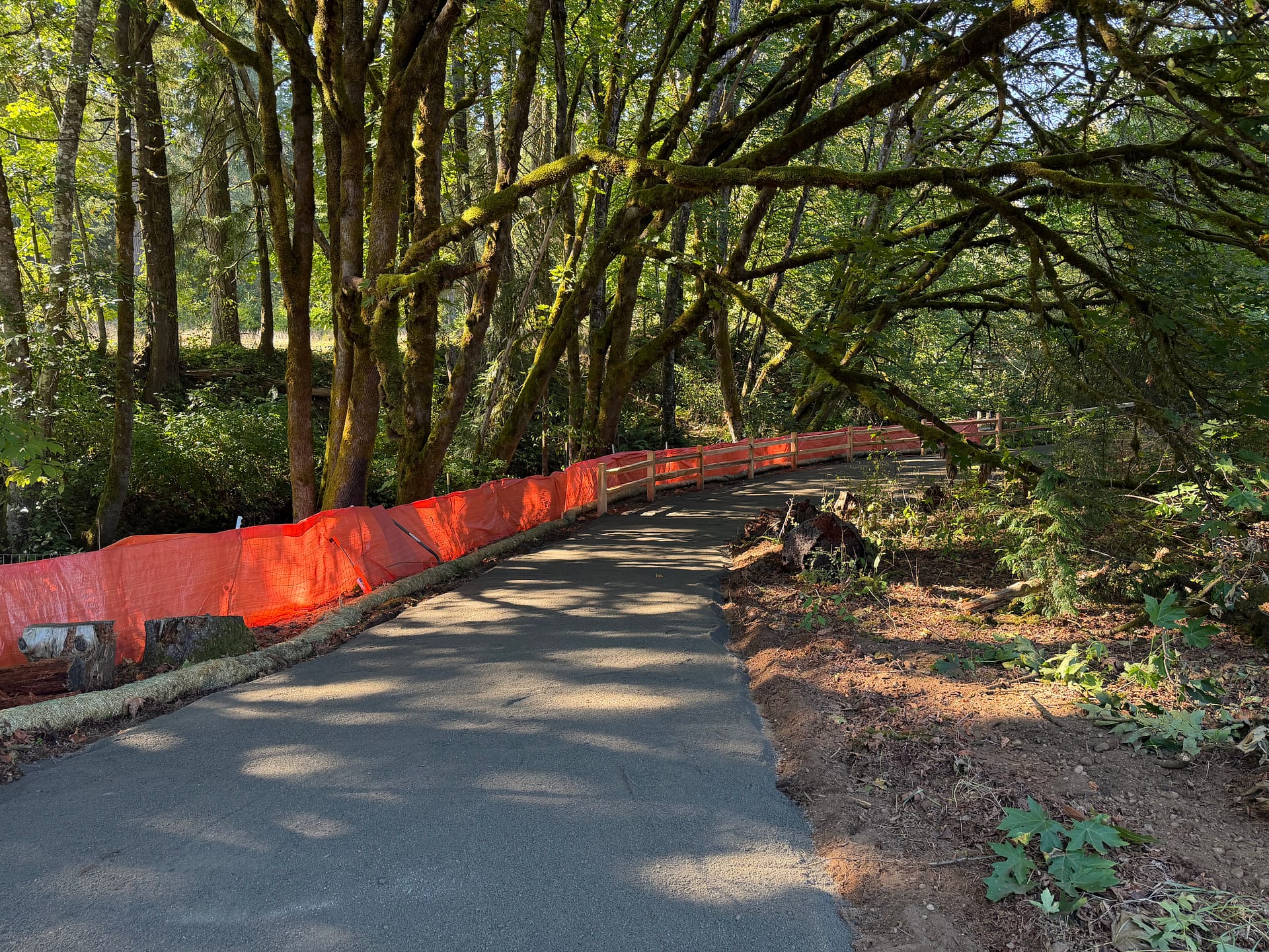
- Improved trail along Johns Creek
-
- Completed, but still closed, new parking lot
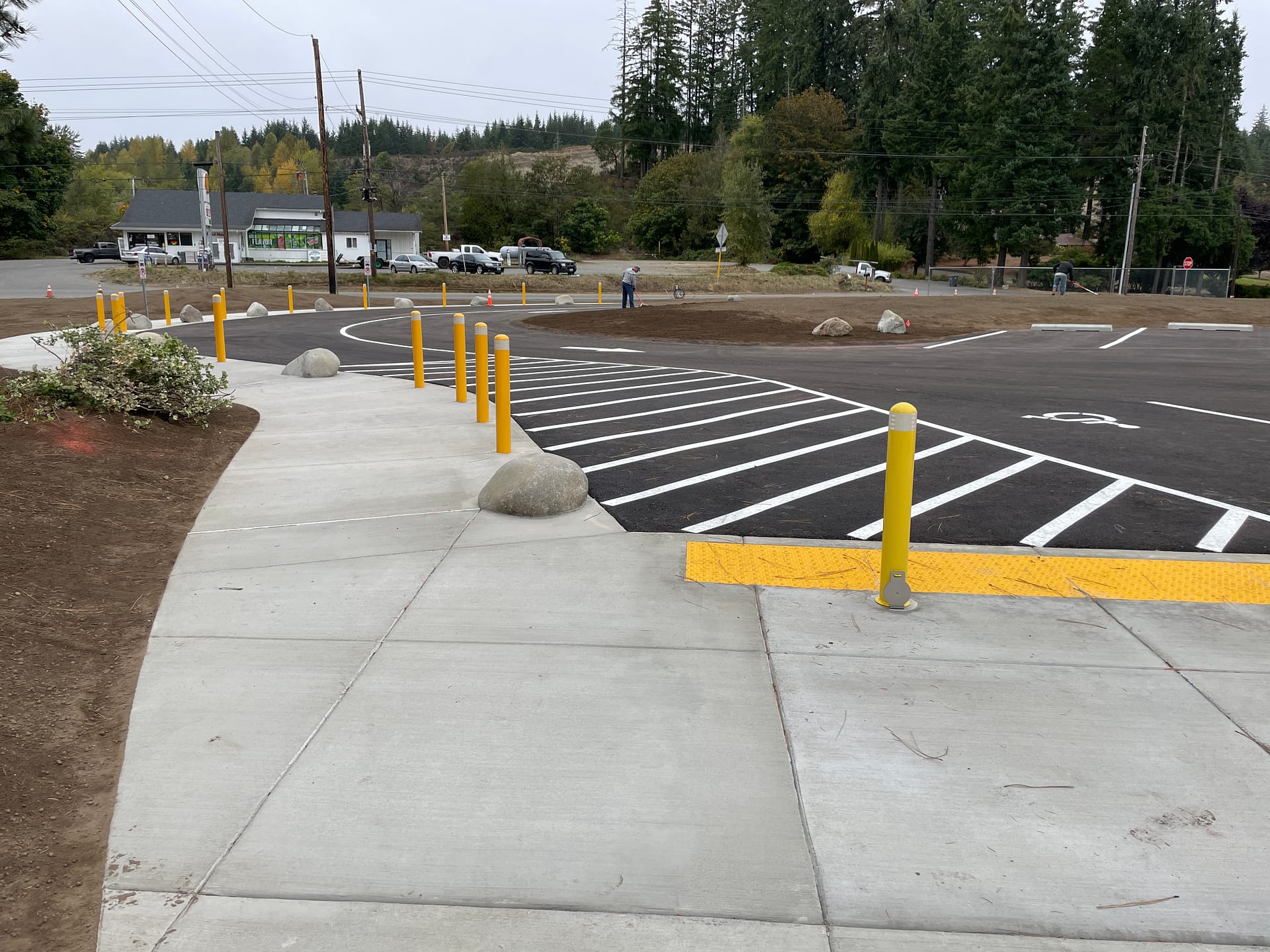
- The new parking lot has been constructed but is not yet open for public use
- Work has begun on regrading and resurfacing the trail from the parking lot to the bridge and along Johns Creek to improve accessibility
- Work has begun on the outdoor classroom
- Planting work has started around the construction site
- Parking: The main lot will be closed during the construction period. Alternative parking is available via Washington Department of Fish & Wildlife’s (WDFW) Oakland Bay Recreation Area at 3990 WA-3 (Discover Pass required—one can be checked out at the library)
- Bathrooms: A portable toilet is available at the Oakland Bay Recreation Area (3990 WA-3)
- Trail Access: Select trails remain open. Refer to the visitor map below for open trails
Map & Visitor Information
Know before you go:
- You may encounter construction noise, equipment, and limited facilities
- Watch for wayfinding signs and stick to the open trails
- Pack in, pack out garbage including pet waste
Thank you for your patience and support as Bayshore Preserve grows into an even better place to explore, learn, and connect.
What We’re Building
We’re building on what people already love about Bayshore—its peaceful trails, open views, and vibrant habitat—while making it easier and more enjoyable to visit.
The work underway includes:
- A redesigned entrance and parking area, including a dedicated van accessible space and room for two full-sized school buses, with bollards and concrete sidewalks for safer access
- A new overflow parking lot with cedar fencing and a crushed rock trail leading directly to the preserve entrance
- A large, visible entrance sign so visitors can easily find their way
- A welcoming plaza with benches, natural features, and a crushed rock surface — a gathering point for families and groups before hitting the trails
- An outdoor classroom designed with educators and community groups in mind, just across the bridge, featuring seating, and crushed gravel surfacing
- Trail upgrades to improve accessibility between the parking area, classroom, and restrooms for visitors using wheelchairs, strollers, or other mobility aids
- Replanting throughout construction areas to ensure long-term habitat health and beauty
Stay Connected
While Bayshore is under construction, we encourage you to explore one of our other public access preserves. Each offers beautiful trails, rich wildlife, and a peaceful place to connect with nature. Discover other nature preserves.
Have questions or want to stay in the loop? Contact us at [email protected] 360.943.3012 or follow us on Facebook and Instagram.
Frequently Asked Questions
We’re redesigning the parking lot and overflow lot, a new and improved Bayshore Preserve sign off Highway 3, new plaza gathering space, an outdoor classroom, and trail upgrades.
Construction is scheduled from July 7 through October 2025, weather dependent.
Alternate access and parking are available via the Washington Department of Fish and Wildlife’s Oakland Bay Recreation Area (3900 WA-3, Shelton). A Discover Pass is required—one can be checked out from the library. Check out our updates page for a trail map.
Visit one of our other public access preserves: Hilburn, Randall, or Darlin Creek preserve. Learn more here.
Since conserving Bayshore Preserve in 2014, Capitol Land Trust has been steadily restoring habitat and improving access. This phase continues that legacy by upgrading infrastructure, improving safety, and expanding accessibility for visitors.
Yes, the preserve will remain open, but with temporary closure of the main parking lot, bathroom, and some trail sections. See trail map. On-site signs will help you navigate the open trails.
Yes! Visit our Bayshore Construction Updates page for construction news, progress photos, and any new visitor guidance throughout the project.