Bayshore Preserve
Conserved in 2014
Learn more about recent improvements at Bayshore Preserve.
Witness the transformation from golf course to nature preserve at Bayshore Preserve! Visitors are welcome to come and enjoy views of Johns Creek and Oakland Bay while witnessing Bayshore Preserve’s transformation from golf course to nature preserve. Long-term plans for the preserve include more accessible trails and viewing platforms to support environmental education programming already taking place here.
Fishing is not allowed on the property, but Capitol Land Trust does provide access via a trail to public land for fishing at the mouth of Johns Creek – see maps on kiosk for directions.
Guidelines:
Open from dawn till dusk.
Keep pets on leash and dispose of waste properly.
No hunting or fishing, boat launching, fires/fireworks, camping or biking.
No removal of vegetation or mushrooms.
Avoid walking in active restoration areas – stay on existing trails.
Location:
3800 WA-3, Shelton, WA 98584. Free parking. Alternative parking is available at the WDFW parking lot to the north of Bayshore Preserve with a Discover Pass.
Transit Options:
Mason County’s free Dial-A-Ride service. Mason County Transit Route 1. There is no marked bus stop at the preserve, so let the driver know when you plan to get off.
Bathroom Information:
There is an ADA-compliant portable toilet with hand sanitizer.
Trail Information:
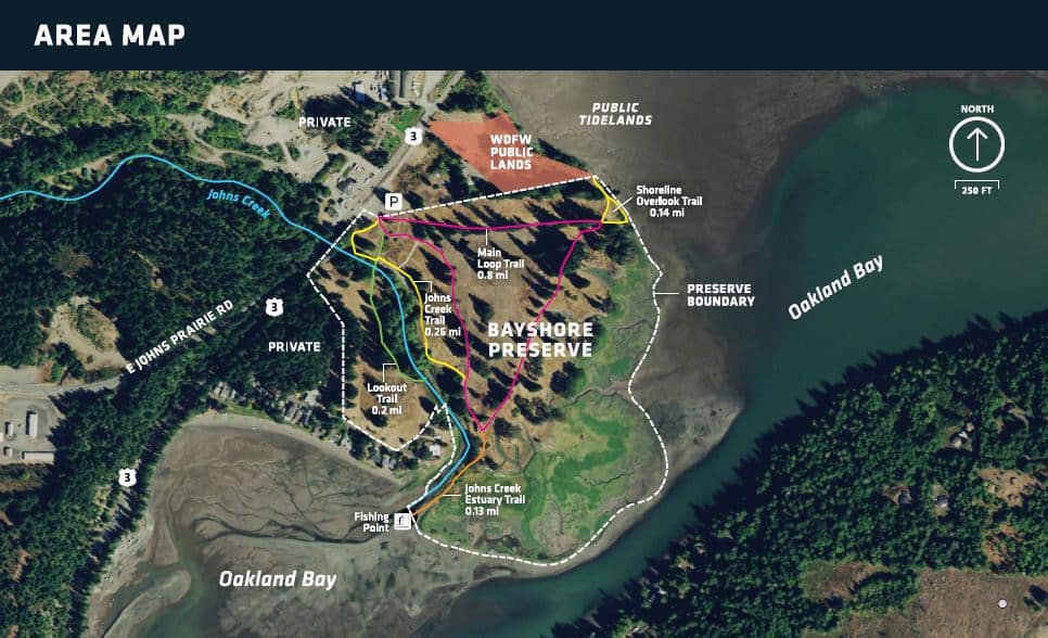
Bayshore Preserve Trail Map
Self-guided interpretive Google map
Bayshore Preserve photo monitoring project
The trail system is about 1.5 miles total. The Main Loop Trail is mostly flat and a mixture of dirt and gravel. Most of this trail was used as a road in the past. The Lookout Trail goes down a gentle slope (5% or less) and across a wide bridge crossing Johns Creek. From there, it heads up a short but steeper hill to a relatively flat trail. Johns Creek Trail is a narrow dirt footpath and has several smaller hills, especially when it meets the Main Loop Trail on the south side of the trail. The Johns Creek Estuary Trail is a dirt path with a dip about halfway down. It can get muddy and wet along this trail, especially during high tide. The Shoreline Overlook Trail is a dirt trail that is relatively flat, but dips slightly towards the water. There are benches located around the entrance and near the bridge that crosses Johns Creek.
Connecting to the Land Campaign
Happening Now at Bayshore Preserve! The Connecting to the Land Campaign is about creating welcoming, accessible places where people can experience nature, learn from it, and build lasting relationships with the lands and waters that sustain our region for years to come. Learn more here.
Help the vision come to life. Donate today at https://capitollandtrust.org/connecting/give
Property Overview:
- 78 acres consisting of a large portion of the Bayshore Peninsula on the western shore of Oakland Bay, Puget Sound.
- Located three miles northwest of Shelton in Mason County, Washington on Oakland Bay.
The property features 27 acres of pristine salt marsh habitat, over 4,000 feet of Oakland Bay shoreline, and the lower portion of Johns Creek. - 47 acres of the property are a former golf course that are being restored to native habitat. Part of the completed restoration includes removal of buildings and a 1,400 foot tidal dike, and the creation of new tidal channels along the marine shoreline and new side channels on Johns Creek.
- Capitol Land Trust permanently returned 250 acre-feet/year of surface water rights, previously used to irrigate the golf course, to instream flow for the benefit of salmon and other wildlife, through the Washington State Trust Water Rights program.
- The Bayshore Peninsula is an important cultural place for the Squaxin Island Tribe, with deep connections to the marine waters and shoreline of South Puget Sound. Historical accounts describe a large village here, including what may have been one of the largest longhouses in the region.
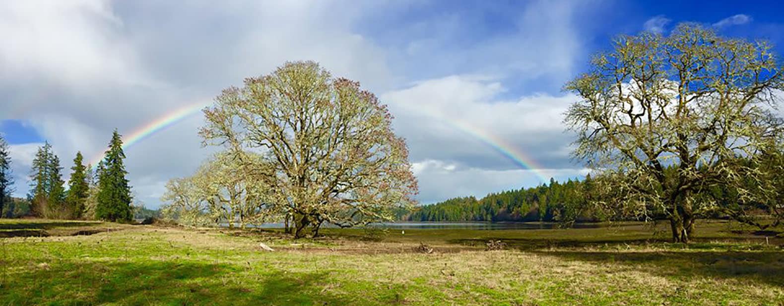
- The property contains very large Douglas-fir trees and both old and young Oregon white oak trees.
- The marine and freshwater ecosystems of Bayshore Preserve provide important habitat for several species of salmon, marine mammals, and a multitude of waterfowl and bird species.
- Check out the Bayshore Preserve birding hotspot on eBird
Thank You to the Following Acquisition & Restoration Partners:
- Squaxin Island Tribe
- US Fish and Wildlife Service
- WA State Department of Ecology
- WA Recreation & Conservation Office
- WRIA 14 Lead Entity
- South Puget Sound Salmon Enhancement Group
- Washington Department of Fish and Wildlife
- US Environmental Protection Agency
- Washington Water Trust
- Shelton-Bayshore Golf Company
- The Trust for Public Land
- Mark Peternell – Bean Gentry Wheeler Peternell, PLLC
- Taylor Shellfish Company, Inc.
- CBRE
- Bayshore Inc.
- ADESA Environmental Services LLC
- Mason County
- WA State Department of Health
- Mason Conservation District
- Bayview and Bayshore neighborhoods
CLT Strategic Conservation Goals Achieved:
- Conserve marine shorelines and estuaries
- Conserve wetlands and riparian areas
- Conserve prairies and oak woodlands
Want to help us care for this preserve? Check out our Trail Steward volunteer opportunity!
Stewardship Corner: Bayshore Preserve
By Steve Kelso Issue 59, Winter 2015
In March, the land trust celebrated the purchase of the former Bayshore Golf Course and adjacent saltmarsh on Oakland Bay near Shelton. It was both the culmination of a thirteen-year effort to protect an important natural asset, and the beginning of ongoing stewardship on the newly named Bayshore Preserve. The stewardship will include: assisting the recovery of a natural area that has been damaged; enhancing the conifer and oak woodlands, Johns Creek, and saltmarsh; and improving the preserve’s ability to nurture wildlife, including chum, coho, and Chinook salmon.
The area has gone through many changes in the last 150 years. Five generations of one family owned the property during most of that time and opened a golf course in the early 1930s. Enoch Willey operated a sawmill beginning about 1870 near the mouth of Johns Creek—originally the site of one of the Squaxin Island Tribe’s largest longhouses and villages. The golf course was sold in the 1950s, but with the recession of 2008, revenue and use of the golf course declined. The owners realized they would need to sell, which is when the land trust stepped in.
The bulk of planned restoration activities for Bayshore Preserve are funded with grants from state and federal agencies, contributions from the Squaxin Island Tribe and Taylor Shellfish Farms, and donated professional services from Mason Conservation District.
Demolition of the buildings was the first part of the restoration process. Another key repair will be the removal of a 1,400-foot dike that holds tidewater back from the old golf course fairways. This, along with grading, sloping, and excavating blocked channels, will allow future tidal flow over an additional ten acres—and the saltmarsh—as sea levels rise.
The return to a more natural state is fostered by retiring the use Bayshore Preserve of Johns Creek water for irrigation of the golf course fairways. As a result, stream flow into the bay will increase, and the land along Johns Creek will recover—naturally and with our help as we remove invasive plants and plant native species. The former golf course acreage also will be planted with native trees and shrubs.
A unique feature of the land is the presence of mature, native Oregon white oak trees along with soils conducive to an oak woodland environment (uncommon in this area) that can provide habitat for the endangered Taylor’s Checkerspot butterfly.
On the preserve’s north border is a Washington Department of Fish and Wildlife (WDFW) water access site, which draws people to harvest shellfish and fish in the bay. Capitol Land Trust is working with WDFW to help ensure that existing and recovering tidal marshes are not damaged by foot traffic. To that end, trails and signage have been enhanced.
In coming years, nature and humans will collaboratively help the preserve’s ecology heal and evolve in ways that are sometimes predictable, sometimes not. Our stewardship includes annual inspections by staff and volunteers to monitor progress and recommend further actions.