• Donate
  • Contact
  • Facebook
  • Instagram
  • YouTube
menu
  • Visit A Preserve
  • Who We Are
    • Our Mission
    • Board & Staff
    • Collaboration
    • Financials
    • Library
  • Get Involved
    • Trail Steward
    • Salmon Docent
    • Stewardship Work Parties
    • K-12 Outdoor Programs
  • Ways To Give
    • Cash
    • Stocks, Donor Advised Funds, IRAs
    • Bequests, Estate Plans & Wills
    • Gifts of Land
    • Other Ways to Give
    • Become a Business Partner
  • Conserved Lands
    • Conservation Map
    • Conserving Key Habitats
    • Conservation Areas
      • Budd & Henderson Inlets
        • Bayfield Resource Co. Forest Conservation Easement
        • Bayfield Resource Co. Gull Harbor Conservation Easement
        • Brown Preserve
        • Cushman Conservation Easement
        • Hale Preserve
        • Harmony Farm Preserve
        • Howe Conservation Easement
        • Lonseth Preserve
        • Scheidt-Mayer Conservation Easement
        • Stephens Preserve
        • Woodland Creek
      • Black River / Chehalis Watershed
        • Aldridge Conservation Easement
        • Baretich Conservation Easement
        • Bergquist Conservation Easement
        • Black River Conservation Easement and Preserve
        • Darlin Creek Preserve
        • Davis Conservation Easement
        • Decker Creek Wetland Complex
        • DeFelice Preserve
        • Edwards Conservation Easement
        • Gordon Farm Conservation Easement
        • Heertje Conservation Easement
        • Holm-Rader Farm Conservation Easement
        • Leitner Prairie Conservation Easements
        • Tilley Wetlands Preserve
        • West Rocky Prairie
      • Cowlitz Watershed
        • Cowlitz River Preserve
      • Deschutes Watershed
        • Anderson Preserve
        • Bentley Conservation Easement
        • Bush Prairie Farm Conservation Easement
        • Parsons Family Farm Conservation Easement
        • Shermer-Deschutes Preserve
        • Springer Lake Preserve
        • Spurgeon Valley Preserve
        • Stewart Conservation Easement
        • Stewart-Deschutes Preserve
        • Yale Preserve
      • Green Cove Creek Wetlands
        • Harper Conservation Easement
        • Kaiser Preserve
        • LOTT Alliance Conservation Easement
        • Ekar-Overhulse Preserve
        • Paul-Leigh Conservation Easement
        • SPSCC Foundation Property
        • YWCA
      • Hood Canal
        • Brothers Beach Conservation Easement
      • Oakland Bay & Goldsborough Creek Watershed
        • Bayshore Preserve
        • Granquist Preserve
        • Hilburn Preserve
        • North Fork Goldsborough Creek Preserve
        • Oakland Bay Historical Park Conservation Easement
        • Olli Conservation Easement
        • Pannell Preserve
        • Rose Preserve
        • North Fork Goldsborough Creek Preserve – Rose Addition
        • Sunset Bluffs
        • Twin Rivers Ranch Preserve
      • Steamboat Conservation Partnership Region
        • Adams Cove Preserve
        • Appleby Conservation Easement
        • Davidson-Bergman Conservation Easement
        • Lower Eld Preserve
        • McIntyre Conservation Easement
        • McLane Point Preserve/Conservation Easement
        • Randall Preserve / Allison Springs
        • Schmidt Conservation Easements
        • Triple Creek Farm Conservation Easement
        • Willits Conservation Easement
        • Willits Tree Farm Conservation Easement
        • Wynne Tree Farm Conservation Easements
    • Inspiring Kids Preserve
    • Conserve Your Land
    • Managing Our Preserves
  • News
  • Events
  • Donate
  • Contact
  • Visit A Preserve
  • Who We Are
    • Our Mission
    • Board & Staff
    • Collaboration
    • Financials
    • Library
  • Get Involved
    • Trail Steward
    • Salmon Docent
    • Stewardship Work Parties
    • K-12 Outdoor Programs
  • Ways To Give
    • Cash
    • Stocks, Donor Advised Funds, IRAs
    • Bequests, Estate Plans & Wills
    • Gifts of Land
    • Other Ways to Give
    • Become a Business Partner
  • Conserved Lands
    • Conservation Map
    • Conserving Key Habitats
    • Conservation Areas
      • Budd & Henderson Inlets
        • Bayfield Resource Co. Forest Conservation Easement
        • Bayfield Resource Co. Gull Harbor Conservation Easement
        • Brown Preserve
        • Cushman Conservation Easement
        • Hale Preserve
        • Harmony Farm Preserve
        • Howe Conservation Easement
        • Lonseth Preserve
        • Scheidt-Mayer Conservation Easement
        • Stephens Preserve
        • Woodland Creek
      • Black River / Chehalis Watershed
        • Aldridge Conservation Easement
        • Baretich Conservation Easement
        • Bergquist Conservation Easement
        • Black River Conservation Easement and Preserve
        • Darlin Creek Preserve
        • Davis Conservation Easement
        • Decker Creek Wetland Complex
        • DeFelice Preserve
        • Edwards Conservation Easement
        • Gordon Farm Conservation Easement
        • Heertje Conservation Easement
        • Holm-Rader Farm Conservation Easement
        • Leitner Prairie Conservation Easements
        • Tilley Wetlands Preserve
        • West Rocky Prairie
      • Cowlitz Watershed
        • Cowlitz River Preserve
      • Deschutes Watershed
        • Anderson Preserve
        • Bentley Conservation Easement
        • Bush Prairie Farm Conservation Easement
        • Parsons Family Farm Conservation Easement
        • Shermer-Deschutes Preserve
        • Springer Lake Preserve
        • Spurgeon Valley Preserve
        • Stewart Conservation Easement
        • Stewart-Deschutes Preserve
        • Yale Preserve
      • Green Cove Creek Wetlands
        • Harper Conservation Easement
        • Kaiser Preserve
        • LOTT Alliance Conservation Easement
        • Ekar-Overhulse Preserve
        • Paul-Leigh Conservation Easement
        • SPSCC Foundation Property
        • YWCA
      • Hood Canal
        • Brothers Beach Conservation Easement
      • Oakland Bay & Goldsborough Creek Watershed
        • Bayshore Preserve
        • Granquist Preserve
        • Hilburn Preserve
        • North Fork Goldsborough Creek Preserve
        • Oakland Bay Historical Park Conservation Easement
        • Olli Conservation Easement
        • Pannell Preserve
        • Rose Preserve
        • North Fork Goldsborough Creek Preserve – Rose Addition
        • Sunset Bluffs
        • Twin Rivers Ranch Preserve
      • Steamboat Conservation Partnership Region
        • Adams Cove Preserve
        • Appleby Conservation Easement
        • Davidson-Bergman Conservation Easement
        • Lower Eld Preserve
        • McIntyre Conservation Easement
        • McLane Point Preserve/Conservation Easement
        • Randall Preserve / Allison Springs
        • Schmidt Conservation Easements
        • Triple Creek Farm Conservation Easement
        • Willits Conservation Easement
        • Willits Tree Farm Conservation Easement
        • Wynne Tree Farm Conservation Easements
    • Inspiring Kids Preserve
    • Conserve Your Land
    • Managing Our Preserves
  • News
  • Events

News Story
April 30, 2025

Salt Marsh and Estuary Conserved in Oakland Bay

CameraChapman Cove Preserve conserves 30 acres of salt and freshwater wetlands and upland habitat. Photo by Mike Melton.

  • ShareShare this post on Facebook
  • Share this post on FacebookTweet
Land Trust Accreditation Commission
Donate Today

Learn More About Us

  • Conserved Lands
  • Conservation Map
  • Conserving Key Habitats
  • Conservation Areas
  • Conserve Your Land
  • Visit A Preserve
  • Inspiring Kids Preserve
  • Managing Our Preserves

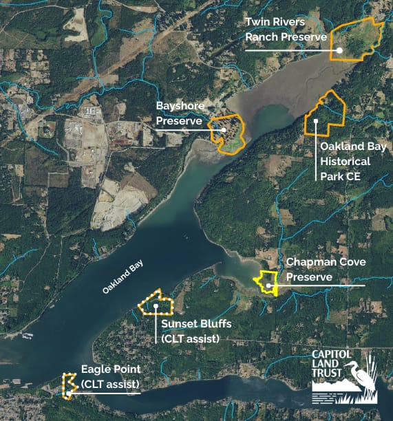
Along the scenic shores of Oakland Bay, Capitol Land Trust’s latest conservation acquisition protects an additional 30 acres in Chapman Cove, including nearly one mile of marine shoreline and the estuary of Uncle John Creek.

The newly protected Chapman Cove Preserve sits on the eastern shore of Oakland Bay. Flanked on the east by Uncle John Creek and near the mouth of Campbell Creek, it one of the last major estuaries within the bay on which Capitol Land Trust (CLT) had yet to establish a conservation foothold. Its shoreline and estuary habitat make the area a conservation priority and adds to a network of estuaries CLT has already conserved in the area.


Salt marsh makes up much of the preserve. The combined salt marsh, estuary and marine shoreline provide habitat for four salmon species: fall chum, coho, coastal cutthroat and winter steelhead. The upland habitat is home to a variety of bird species like Hutton’s vireo, pileated woodpecker, red-breasted nuthatch and pine siskin.

“We want wildlife to thrive now and into the future. Chapman Cove Preserve is part of a growing network of CLT-conserved lands on Hammersley Inlet and Oakland Bay that provide habitat connectivity and ecosystem integrity, supporting a variety of key fish and wildlife species. This project represents a significant milestone in our Oakland Bay conservation strategy as it permanently protects an additional mile of marine shoreline and estuarine habitat in Chapman Cove.”
– Alexandra James, Conservation Director

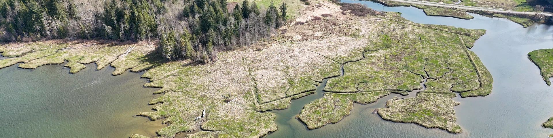
Facing NW over the newly conserved Chapman Cove Preserve towards the larger Oakland Bay. Photo by Mike Melton.

Salt marshes are more than scenic, they are essential to life.

Salt marshes are among the most biologically productive coastal habitats in the world. They form when mud, silt and decomposing plant matter build up along a sheltered part of the coastline. They often form near a river or creek where sediment is deposited. Over time, the surface builds up and salt tolerant plants begin to grow.

Substantial nutrients are available in salt marshes due to their unique position in the intertidal zone and near a freshwater source. Microorganisms and tiny insects have the necessary food they need to thrive and are eaten by larger animals. Larger animals are in turn eaten by even larger organisms.

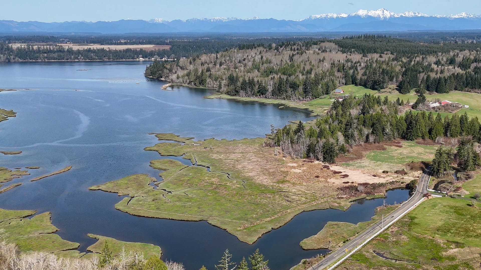
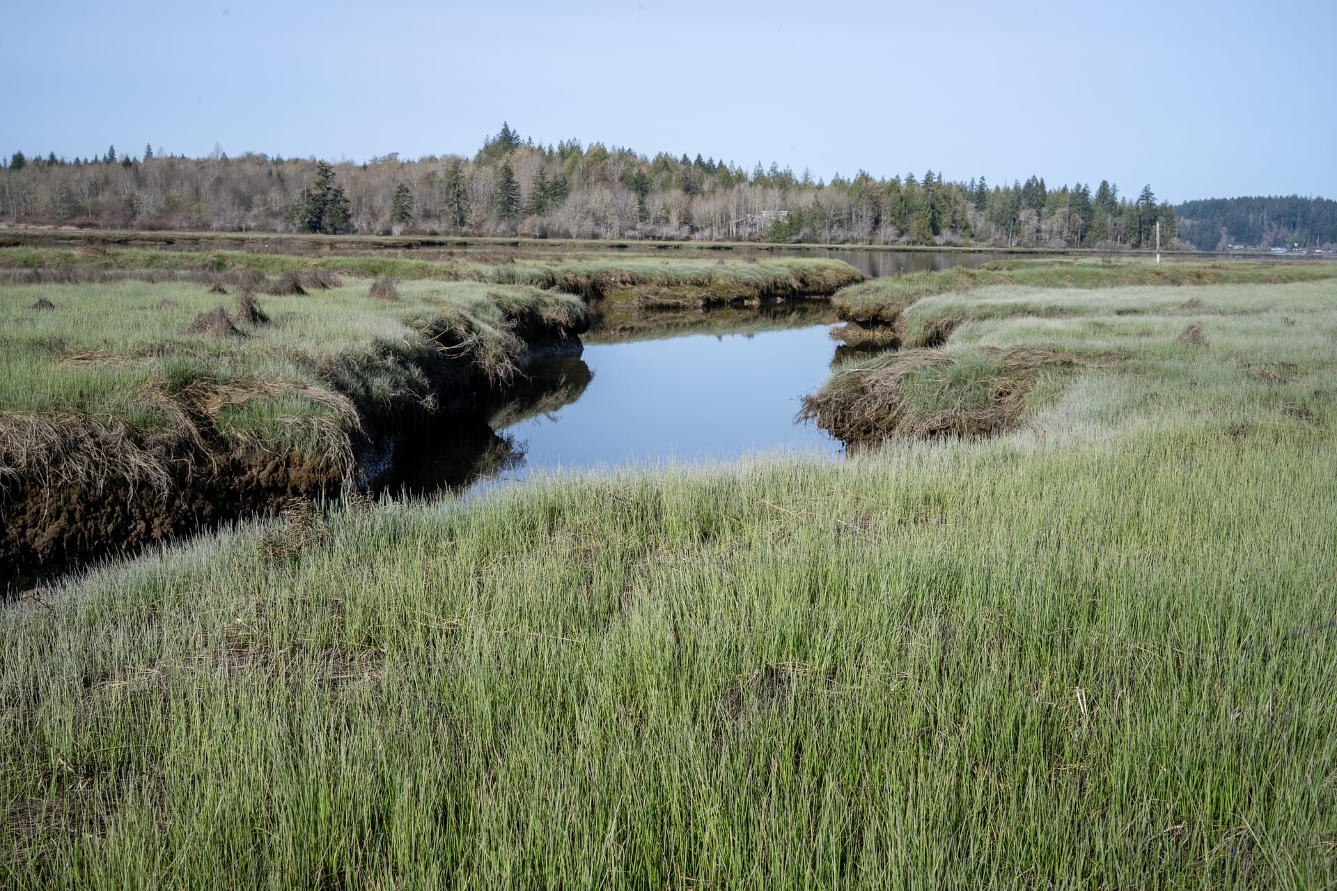
The salt marsh just after high tide. Chapman Cove Preserve protects over 23 acres of salt and freshwater wetlands. Photo by CLT.

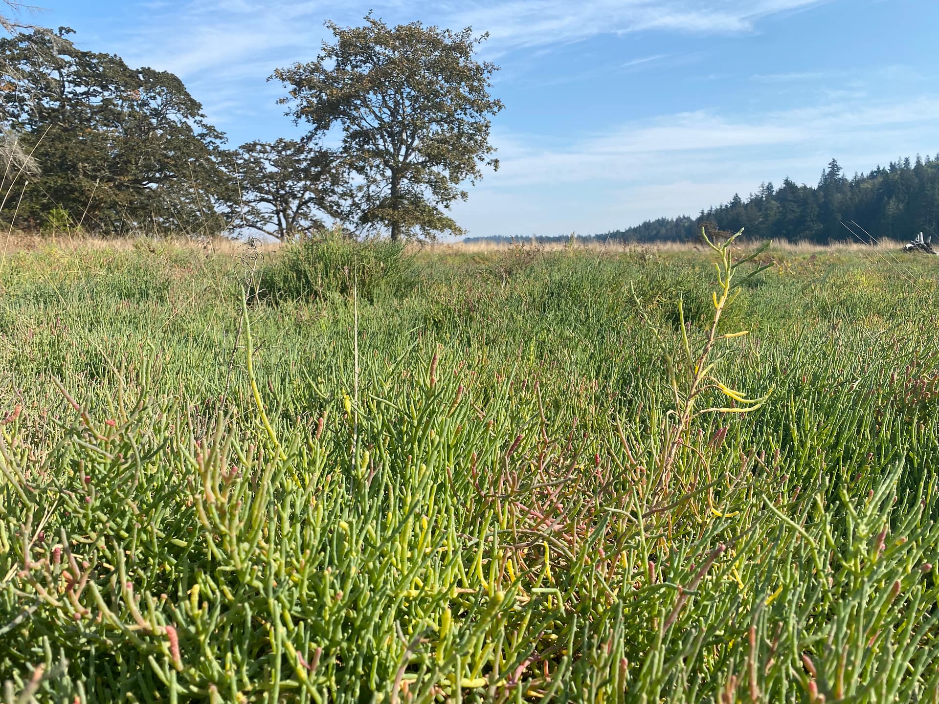
Many specially adapted plants grow in salt marshes. Since these areas are often covered and uncovered by high tides, they can be exposed to a lot of salt. Pickleweed, gumweed, goosefoot and salt grass are common salt marsh pants in our region of South Puget Sound.

Pickleweed is a succulent plant adapted for salty water. Some salt is filtered at the roots and excess salt gets stored in the tips of the plants above ground segments. When full of salt, the tips turn red and fall off. Photo by CLT.

Salt marshes fulfill an important role in the larger aquatic ecosystem. Just as nutrients are brought to the salt marsh, nutrients also flow from the salt marsh with the tides and out to the larger Puget Sound, and even the ocean.

The permanent conservation of the 30-acre Chapman Cove Preserve ensures a myriad of wildlife have the sustenance they need to survive.

CLT’s conservation strategy for the Oakland Bay watershed prioritizes the protection of estuaries, marine shoreline, and the surrounding land. We will continue to steward the land by managing invasive plant species.

Donations help us conserve important habitat like Chapman Cove, forever. If you support our work, donate today.

  • Facebook
  • Instragram
  • Youtube

  • PO Box 14065
  • Tumwater, WA 98511
  • Telephone: (360) 943-3012
  • Email:

  • Who We Are
  • Our Mission
  • Board & Staff
  • Collaboration
  • Financials
  • Library
  • Careers
  • Get Involved
  • Trail Steward
  • Stewardship Work Parties
  • Salmon Docent
  • K-12 Outdoor Programs
  • Ways To Give
  • Cash
  • Other Ways to Give
  • Become a Business Partner
  • Gifts of Land
  • Bequests, Estate Plans & Wills
  • Stocks, Donor Advised Funds, IRAs
  • Conserved Lands
  • Conservation Map
  • Conserving Key Habitats
  • Conservation Areas
  • Conserve Your Land
  • Visit A Preserve
  • Inspiring Kids Preserve
  • Managing Our Preserves
  • Donate
  • Contact
  • Events
  • News

Copyright © Capitol Land Trust All Rights Reserved. | Made by SlowClouds