• Donate
  • Contact
  • Facebook
  • Instagram
  • YouTube
menu
  • Visit A Preserve
  • Who We Are
    • Our Mission
    • Board & Staff
    • Collaboration
    • Financials
    • Library
  • Get Involved
    • Trail Steward
    • Salmon Docent
    • Stewardship Work Parties
    • K-12 Outdoor Programs
  • Ways To Give
    • Cash
    • Stocks, Donor Advised Funds, IRAs
    • Bequests, Estate Plans & Wills
    • Gifts of Land
    • Other Ways to Give
    • Become a Business Partner
  • Conserved Lands
    • Conservation Map
    • Conserving Key Habitats
    • Conservation Areas
      • Budd & Henderson Inlets
        • Bayfield Resource Co. Forest Conservation Easement
        • Bayfield Resource Co. Gull Harbor Conservation Easement
        • Brown Preserve
        • Cushman Conservation Easement
        • Hale Preserve
        • Harmony Farm Preserve
        • Howe Conservation Easement
        • Lonseth Preserve
        • Scheidt-Mayer Conservation Easement
        • Stephens Preserve
        • Woodland Creek
      • Black River / Chehalis Watershed
        • Aldridge Conservation Easement
        • Baretich Conservation Easement
        • Bergquist Conservation Easement
        • Black River Conservation Easement and Preserve
        • Darlin Creek Preserve
        • Davis Conservation Easement
        • Decker Creek Wetland Complex
        • DeFelice Preserve
        • Edwards Conservation Easement
        • Gordon Farm Conservation Easement
        • Heertje Conservation Easement
        • Holm-Rader Farm Conservation Easement
        • Leitner Prairie Conservation Easements
        • Tilley Wetlands Preserve
        • West Rocky Prairie
      • Cowlitz Watershed
        • Cowlitz River Preserve
      • Deschutes Watershed
        • Anderson Preserve
        • Bentley Conservation Easement
        • Bush Prairie Farm Conservation Easement
        • Parsons Family Farm Conservation Easement
        • Shermer-Deschutes Preserve
        • Springer Lake Preserve
        • Spurgeon Valley Preserve
        • Stewart Conservation Easement
        • Stewart-Deschutes Preserve
        • Yale Preserve
      • Green Cove Creek Wetlands
        • Harper Conservation Easement
        • Kaiser Preserve
        • LOTT Alliance Conservation Easement
        • Ekar-Overhulse Preserve
        • Paul-Leigh Conservation Easement
        • SPSCC Foundation Property
        • YWCA
      • Hood Canal
        • Brothers Beach Conservation Easement
      • Oakland Bay & Goldsborough Creek Watershed
        • Bayshore Preserve
        • Granquist Preserve
        • Hilburn Preserve
        • North Fork Goldsborough Creek Preserve
        • Oakland Bay Historical Park Conservation Easement
        • Olli Conservation Easement
        • Pannell Preserve
        • Rose Preserve
        • North Fork Goldsborough Creek Preserve – Rose Addition
        • Sunset Bluffs
        • Twin Rivers Ranch Preserve
      • Steamboat Conservation Partnership Region
        • Adams Cove Preserve
        • Appleby Conservation Easement
        • Davidson-Bergman Conservation Easement
        • Lower Eld Preserve
        • McIntyre Conservation Easement
        • McLane Point Preserve/Conservation Easement
        • Randall Preserve / Allison Springs
        • Schmidt Conservation Easements
        • Triple Creek Farm Conservation Easement
        • Willits Conservation Easement
        • Willits Tree Farm Conservation Easement
        • Wynne Tree Farm Conservation Easements
    • Inspiring Kids Preserve
    • Conserve Your Land
    • Managing Our Preserves
  • News
  • Events
  • Donate
  • Contact
  • Visit A Preserve
  • Who We Are
    • Our Mission
    • Board & Staff
    • Collaboration
    • Financials
    • Library
  • Get Involved
    • Trail Steward
    • Salmon Docent
    • Stewardship Work Parties
    • K-12 Outdoor Programs
  • Ways To Give
    • Cash
    • Stocks, Donor Advised Funds, IRAs
    • Bequests, Estate Plans & Wills
    • Gifts of Land
    • Other Ways to Give
    • Become a Business Partner
  • Conserved Lands
    • Conservation Map
    • Conserving Key Habitats
    • Conservation Areas
      • Budd & Henderson Inlets
        • Bayfield Resource Co. Forest Conservation Easement
        • Bayfield Resource Co. Gull Harbor Conservation Easement
        • Brown Preserve
        • Cushman Conservation Easement
        • Hale Preserve
        • Harmony Farm Preserve
        • Howe Conservation Easement
        • Lonseth Preserve
        • Scheidt-Mayer Conservation Easement
        • Stephens Preserve
        • Woodland Creek
      • Black River / Chehalis Watershed
        • Aldridge Conservation Easement
        • Baretich Conservation Easement
        • Bergquist Conservation Easement
        • Black River Conservation Easement and Preserve
        • Darlin Creek Preserve
        • Davis Conservation Easement
        • Decker Creek Wetland Complex
        • DeFelice Preserve
        • Edwards Conservation Easement
        • Gordon Farm Conservation Easement
        • Heertje Conservation Easement
        • Holm-Rader Farm Conservation Easement
        • Leitner Prairie Conservation Easements
        • Tilley Wetlands Preserve
        • West Rocky Prairie
      • Cowlitz Watershed
        • Cowlitz River Preserve
      • Deschutes Watershed
        • Anderson Preserve
        • Bentley Conservation Easement
        • Bush Prairie Farm Conservation Easement
        • Parsons Family Farm Conservation Easement
        • Shermer-Deschutes Preserve
        • Springer Lake Preserve
        • Spurgeon Valley Preserve
        • Stewart Conservation Easement
        • Stewart-Deschutes Preserve
        • Yale Preserve
      • Green Cove Creek Wetlands
        • Harper Conservation Easement
        • Kaiser Preserve
        • LOTT Alliance Conservation Easement
        • Ekar-Overhulse Preserve
        • Paul-Leigh Conservation Easement
        • SPSCC Foundation Property
        • YWCA
      • Hood Canal
        • Brothers Beach Conservation Easement
      • Oakland Bay & Goldsborough Creek Watershed
        • Bayshore Preserve
        • Granquist Preserve
        • Hilburn Preserve
        • North Fork Goldsborough Creek Preserve
        • Oakland Bay Historical Park Conservation Easement
        • Olli Conservation Easement
        • Pannell Preserve
        • Rose Preserve
        • North Fork Goldsborough Creek Preserve – Rose Addition
        • Sunset Bluffs
        • Twin Rivers Ranch Preserve
      • Steamboat Conservation Partnership Region
        • Adams Cove Preserve
        • Appleby Conservation Easement
        • Davidson-Bergman Conservation Easement
        • Lower Eld Preserve
        • McIntyre Conservation Easement
        • McLane Point Preserve/Conservation Easement
        • Randall Preserve / Allison Springs
        • Schmidt Conservation Easements
        • Triple Creek Farm Conservation Easement
        • Willits Conservation Easement
        • Willits Tree Farm Conservation Easement
        • Wynne Tree Farm Conservation Easements
    • Inspiring Kids Preserve
    • Conserve Your Land
    • Managing Our Preserves
  • News
  • Events

News Story
August 30, 2021

Conservation Success! Expansion of Conserved Land on the Skookumchuck River

CameraSkookumchuck Forest Preserve, Mike Melton

  • ShareShare this post on Facebook
  • Share this post on FacebookTweet
Land Trust Accreditation Commission
Donate Today

Learn More About Us

  • Conserved Lands
  • Conservation Map
  • Conserving Key Habitats
  • Conservation Areas
  • Conserve Your Land
  • Visit A Preserve
  • Inspiring Kids Preserve
  • Managing Our Preserves

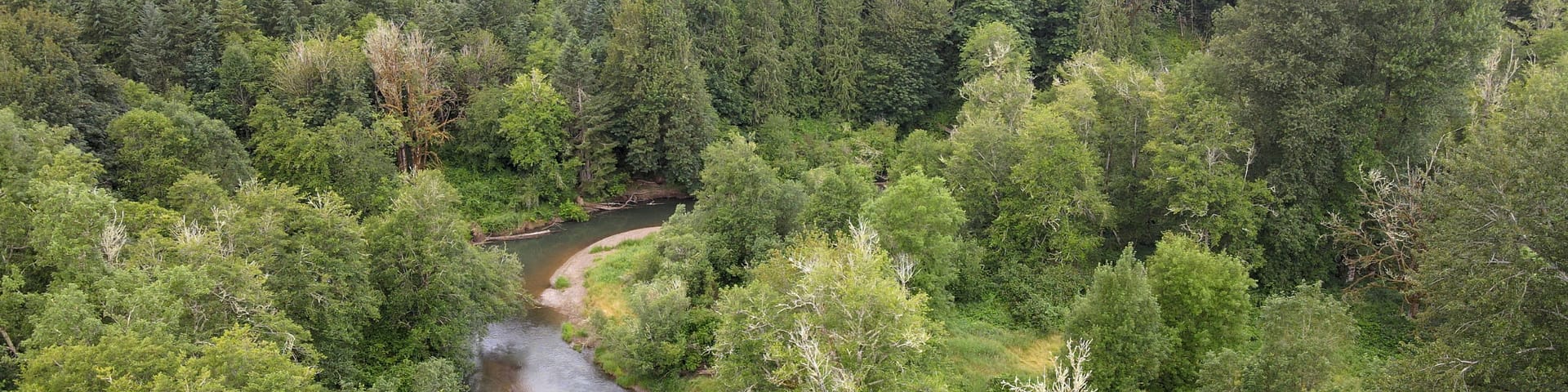
Capitol Land Trust (CLT) is pleased to announce the conservation of Skookumchuck Forest Preserve. The preserve was named for its beautiful stream-side vegetation along the Skookumchuck River. The property was purchased from Green Diamond Resource Company and is adjacent to CLT’s Mueller Conservation Easement, conserved in 2020. Combined, these properties conserve substantial shoreline along the river, allowing for extensive restoration work.

“This 28-acre property, although small by itself, is adjacent to our 74-acre Mueller Conservation Easement, which combined conserves almost 1.5 miles of critical salmon habitat in the Skookumchuck River. Between the intact riparian forest on the Skookumchuck Forest Preserve and the restoration work on the Mueller easment shoreline, this will one day be almost three miles of highly functional riparian habitat, benefiting both aquatic and terrestrial species alike.” – Laurence Reeves, Conservation Director, Capitol Land Trust


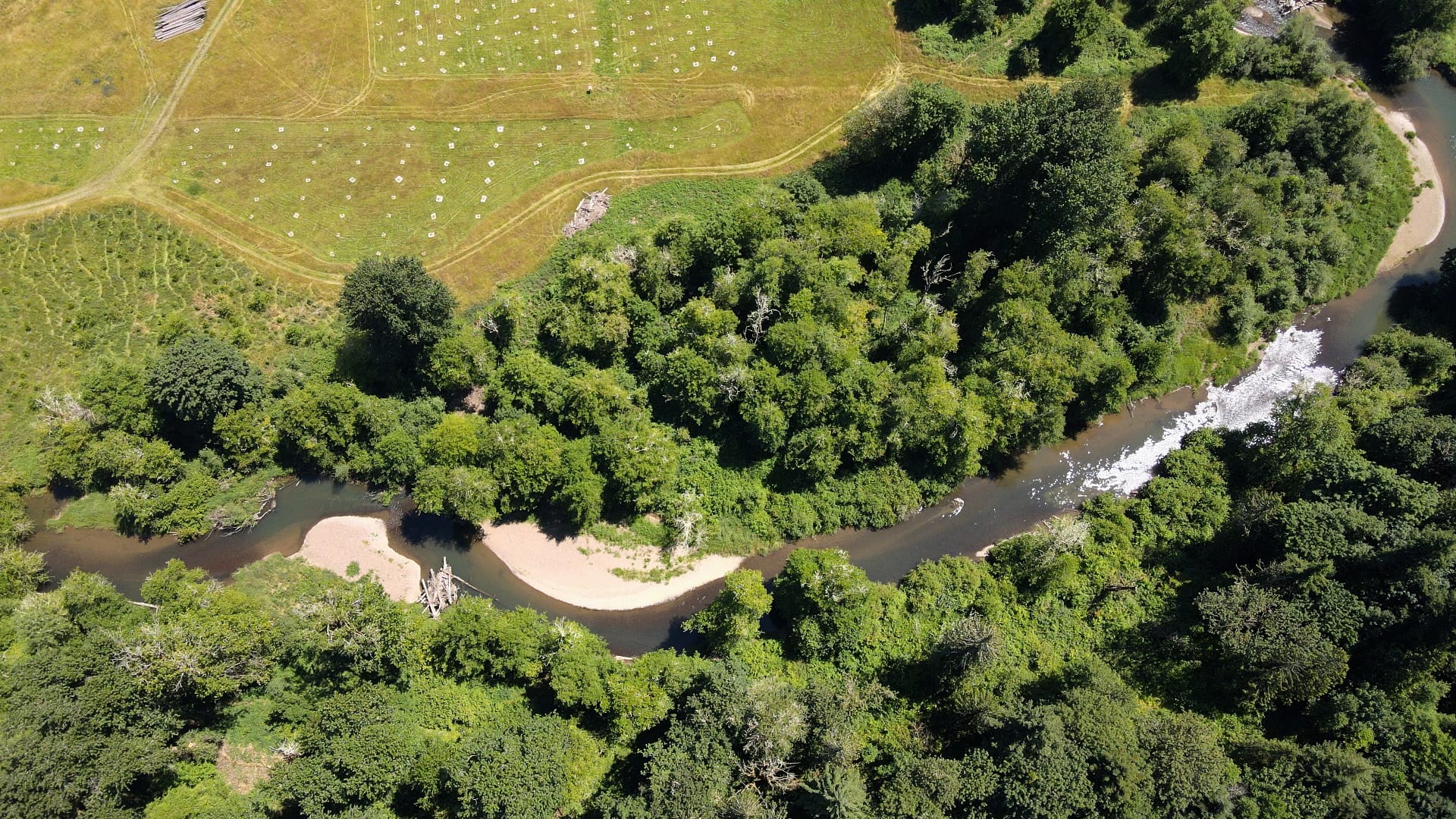
The Skookumchuck River shoreline and upland forest of these two properties provide important habitat for spring and fall Chinook salmon, coho salmon, winter steelhead, and a myriad of other species. Led by the Washington Department of Fish & Wildlife and Thurston Conservation District, restoration is underway along the riverbanks and in the river itself. Thousands of native plants have been added along the riverbanks and logjams have been added in the river to help rebuild a complex ecosystem. In-stream structures like logjams provide hiding and resting places for young fish and other aquatic species, which helps them fulfill their role in the ecosystem.

https://capitollandtrust.org/wp-content/uploads/2021/08/log-jam-video.mp4

“With the Skookumchuck Dam upstream of the project area, there are few opportunities for natural recruitment of large wood in this section of the river, which is an important element of a healthy ecosystem. Through the conservation of the river corridor, construction of engineered logjams, and installation of thousands of native riparian and upland plantings, the project supports a healthy stretch of river that will persist for generations. This project would not be a reality without the strong partnerships cultivated between Washington Department of Fish and Wildlife, Capitol Land Trust, Thurston Conservation District, and private landowners who each played a role in taking the first step towards revitalizing this important place.”
– Celina Abercrombie, Chehalis Basin Strategy Manager, Washington Department of Fish & Wildlife

Conservation strategies are often developed in the context of watersheds. A watershed is an area of land that contains a common set of streams and rivers that all drain into a larger water body. The largest watersheds are called basins. Skookumchuck Forest Preserve and the Mueller Conservation Easement are part of the Chehalis Basin. The Chehalis Basin is the second largest watershed in Washington state. The Skookumchuck River makes up a southern portion of the Chehalis Basin and flows into the Chehalis River near Centralia. The Chehalis River eventually empties into Grays Harbor on the Pacific Coast.

Chehalis Basin, Dept. of Ecology

The Chehalis Basin has been home to the People of the Sands, now the Confederated Tribes of the Chehalis Reservation, since time immemorial. According to the Chehalis Tribe, two large groups of Salish-speaking people historically lived along the Chehalis River and gathered roots, berries, fish, and elk from the surrounding area. Many years after European settlement, land use in this watershed is mainly agriculture and forestry.

Although this basin is one of the only remaining river basins in Washington state where salmon species are not listed as threatened or endangered, it faces significant challenges. Major flooding events and the rapid depletion of aquatic species habitat threaten the basin’s economic and ecologic value to the state and region. In response to these issues, the state legislature created the Office of Chehalis Basin (OCB) and established the Chehalis Basin Board to provide long-term oversight of the strategy. The Board has representatives from the Quinault Indian Nation, the Confederated Tribes of the Chehalis Reservation, and the Chehalis River Basin Flood Authority, in addition to agricultural, environmental, and economic interests.

The OCB implements a science-based plan called the Chehalis Basin Strategy. This strategy is a list of potential actions to address extreme flooding and degraded habitat within the Chehalis Basin. A key part of the strategy is the Aquatic Species Restoration Plan, which is designed to restore aquatic species habitat and enhance local economies. The conservation and restoration of Skookumchuck Forest Preserve and the adjacent Mueller Conservation Easement are just one part of this larger strategy to improve the health of the Chehalis Basin.

Skookumchuck River log jams and plantings on the two properties

The Aquatic Species Restoration Plan opens the door to new conservation opportunities in the Chehalis Basin. CLT is proud to be a part of a multi-agency team that honors existing community values, builds on previous actions to protect and restore basin habitat and ecological processes, and complements investments the state has already made in habitat restoration and protection.

Learn more about the Chehalis Basin Strategy here.

Thank you to our project partners:

  • Forterra
  • Green Diamond Resource Company
  • Office of Chehalis Basin
  • Thurston Conservation District
  • WA Recreation and Conservation Office
  • WA Department of Ecology
  • WA Department of Fish and Wildlife
  • Facebook
  • Instragram
  • Youtube

  • PO Box 14065
  • Tumwater, WA 98511
  • Telephone: (360) 943-3012
  • Email:

  • Who We Are
  • Our Mission
  • Board & Staff
  • Collaboration
  • Financials
  • Library
  • Careers
  • Get Involved
  • Trail Steward
  • Stewardship Work Parties
  • Salmon Docent
  • K-12 Outdoor Programs
  • Ways To Give
  • Cash
  • Other Ways to Give
  • Become a Business Partner
  • Gifts of Land
  • Bequests, Estate Plans & Wills
  • Stocks, Donor Advised Funds, IRAs
  • Conserved Lands
  • Conservation Map
  • Conserving Key Habitats
  • Conservation Areas
  • Conserve Your Land
  • Visit A Preserve
  • Inspiring Kids Preserve
  • Managing Our Preserves
  • Donate
  • Contact
  • Events
  • News

Copyright © Capitol Land Trust All Rights Reserved. | Made by SlowClouds