• Donate
  • Contact
  • Facebook
  • Instagram
  • YouTube
menu
  • Visit A Preserve
  • Who We Are
    • Our Mission
    • Board & Staff
    • Collaboration
    • Financials
    • Library
  • Get Involved
    • Trail Steward
    • Salmon Docent
    • Stewardship Work Parties
    • K-12 Outdoor Programs
  • Ways To Give
    • Cash
    • Stocks, Donor Advised Funds, IRAs
    • Bequests, Estate Plans & Wills
    • Gifts of Land
    • Other Ways to Give
    • Become a Business Partner
  • Conserved Lands
    • Conservation Map
    • Conserving Key Habitats
    • Conservation Areas
      • Budd & Henderson Inlets
        • Bayfield Resource Co. Forest Conservation Easement
        • Bayfield Resource Co. Gull Harbor Conservation Easement
        • Brown Preserve
        • Cushman Conservation Easement
        • Hale Preserve
        • Harmony Farm Preserve
        • Howe Conservation Easement
        • Lonseth Preserve
        • Scheidt-Mayer Conservation Easement
        • Stephens Preserve
        • Woodland Creek
      • Black River / Chehalis Watershed
        • Aldridge Conservation Easement
        • Baretich Conservation Easement
        • Bergquist Conservation Easement
        • Black River Conservation Easement and Preserve
        • Darlin Creek Preserve
        • Davis Conservation Easement
        • Decker Creek Wetland Complex
        • DeFelice Preserve
        • Edwards Conservation Easement
        • Gordon Farm Conservation Easement
        • Heertje Conservation Easement
        • Holm-Rader Farm Conservation Easement
        • Leitner Prairie Conservation Easements
        • Tilley Wetlands Preserve
        • West Rocky Prairie
      • Cowlitz Watershed
        • Cowlitz River Preserve
      • Deschutes Watershed
        • Anderson Preserve
        • Bentley Conservation Easement
        • Bush Prairie Farm Conservation Easement
        • Parsons Family Farm Conservation Easement
        • Shermer-Deschutes Preserve
        • Springer Lake Preserve
        • Spurgeon Valley Preserve
        • Stewart Conservation Easement
        • Stewart-Deschutes Preserve
        • Yale Preserve
      • Green Cove Creek Wetlands
        • Harper Conservation Easement
        • Kaiser Preserve
        • LOTT Alliance Conservation Easement
        • Ekar-Overhulse Preserve
        • Paul-Leigh Conservation Easement
        • SPSCC Foundation Property
        • YWCA
      • Hood Canal
        • Brothers Beach Conservation Easement
      • Oakland Bay & Goldsborough Creek Watershed
        • Bayshore Preserve
        • Granquist Preserve
        • Hilburn Preserve
        • North Fork Goldsborough Creek Preserve
        • Oakland Bay Historical Park Conservation Easement
        • Olli Conservation Easement
        • Pannell Preserve
        • Rose Preserve
        • North Fork Goldsborough Creek Preserve – Rose Addition
        • Sunset Bluffs
        • Twin Rivers Ranch Preserve
      • Steamboat Conservation Partnership Region
        • Adams Cove Preserve
        • Appleby Conservation Easement
        • Davidson-Bergman Conservation Easement
        • Lower Eld Preserve
        • McIntyre Conservation Easement
        • McLane Point Preserve/Conservation Easement
        • Randall Preserve / Allison Springs
        • Schmidt Conservation Easements
        • Triple Creek Farm Conservation Easement
        • Willits Conservation Easement
        • Willits Tree Farm Conservation Easement
        • Wynne Tree Farm Conservation Easements
    • Inspiring Kids Preserve
    • Conserve Your Land
    • Managing Our Preserves
  • News
  • Events
  • Donate
  • Contact
  • Visit A Preserve
  • Who We Are
    • Our Mission
    • Board & Staff
    • Collaboration
    • Financials
    • Library
  • Get Involved
    • Trail Steward
    • Salmon Docent
    • Stewardship Work Parties
    • K-12 Outdoor Programs
  • Ways To Give
    • Cash
    • Stocks, Donor Advised Funds, IRAs
    • Bequests, Estate Plans & Wills
    • Gifts of Land
    • Other Ways to Give
    • Become a Business Partner
  • Conserved Lands
    • Conservation Map
    • Conserving Key Habitats
    • Conservation Areas
      • Budd & Henderson Inlets
        • Bayfield Resource Co. Forest Conservation Easement
        • Bayfield Resource Co. Gull Harbor Conservation Easement
        • Brown Preserve
        • Cushman Conservation Easement
        • Hale Preserve
        • Harmony Farm Preserve
        • Howe Conservation Easement
        • Lonseth Preserve
        • Scheidt-Mayer Conservation Easement
        • Stephens Preserve
        • Woodland Creek
      • Black River / Chehalis Watershed
        • Aldridge Conservation Easement
        • Baretich Conservation Easement
        • Bergquist Conservation Easement
        • Black River Conservation Easement and Preserve
        • Darlin Creek Preserve
        • Davis Conservation Easement
        • Decker Creek Wetland Complex
        • DeFelice Preserve
        • Edwards Conservation Easement
        • Gordon Farm Conservation Easement
        • Heertje Conservation Easement
        • Holm-Rader Farm Conservation Easement
        • Leitner Prairie Conservation Easements
        • Tilley Wetlands Preserve
        • West Rocky Prairie
      • Cowlitz Watershed
        • Cowlitz River Preserve
      • Deschutes Watershed
        • Anderson Preserve
        • Bentley Conservation Easement
        • Bush Prairie Farm Conservation Easement
        • Parsons Family Farm Conservation Easement
        • Shermer-Deschutes Preserve
        • Springer Lake Preserve
        • Spurgeon Valley Preserve
        • Stewart Conservation Easement
        • Stewart-Deschutes Preserve
        • Yale Preserve
      • Green Cove Creek Wetlands
        • Harper Conservation Easement
        • Kaiser Preserve
        • LOTT Alliance Conservation Easement
        • Ekar-Overhulse Preserve
        • Paul-Leigh Conservation Easement
        • SPSCC Foundation Property
        • YWCA
      • Hood Canal
        • Brothers Beach Conservation Easement
      • Oakland Bay & Goldsborough Creek Watershed
        • Bayshore Preserve
        • Granquist Preserve
        • Hilburn Preserve
        • North Fork Goldsborough Creek Preserve
        • Oakland Bay Historical Park Conservation Easement
        • Olli Conservation Easement
        • Pannell Preserve
        • Rose Preserve
        • North Fork Goldsborough Creek Preserve – Rose Addition
        • Sunset Bluffs
        • Twin Rivers Ranch Preserve
      • Steamboat Conservation Partnership Region
        • Adams Cove Preserve
        • Appleby Conservation Easement
        • Davidson-Bergman Conservation Easement
        • Lower Eld Preserve
        • McIntyre Conservation Easement
        • McLane Point Preserve/Conservation Easement
        • Randall Preserve / Allison Springs
        • Schmidt Conservation Easements
        • Triple Creek Farm Conservation Easement
        • Willits Conservation Easement
        • Willits Tree Farm Conservation Easement
        • Wynne Tree Farm Conservation Easements
    • Inspiring Kids Preserve
    • Conserve Your Land
    • Managing Our Preserves
  • News
  • Events

Camera Photo by Terry Liberty

  • ShareShare this post on Facebook
  • Share this post on FacebookTweet
Land Trust Accreditation Commission
Donate Today

Learn More About Us

  • Conserved Lands
  • Conservation Map
  • Conserving Key Habitats
  • Conservation Areas
  • Conserve Your Land
  • Visit A Preserve
  • Inspiring Kids Preserve
  • Managing Our Preserves

Oakland Bay Historical Park Conservation Easement

Conserved in 2005

Property Overview:

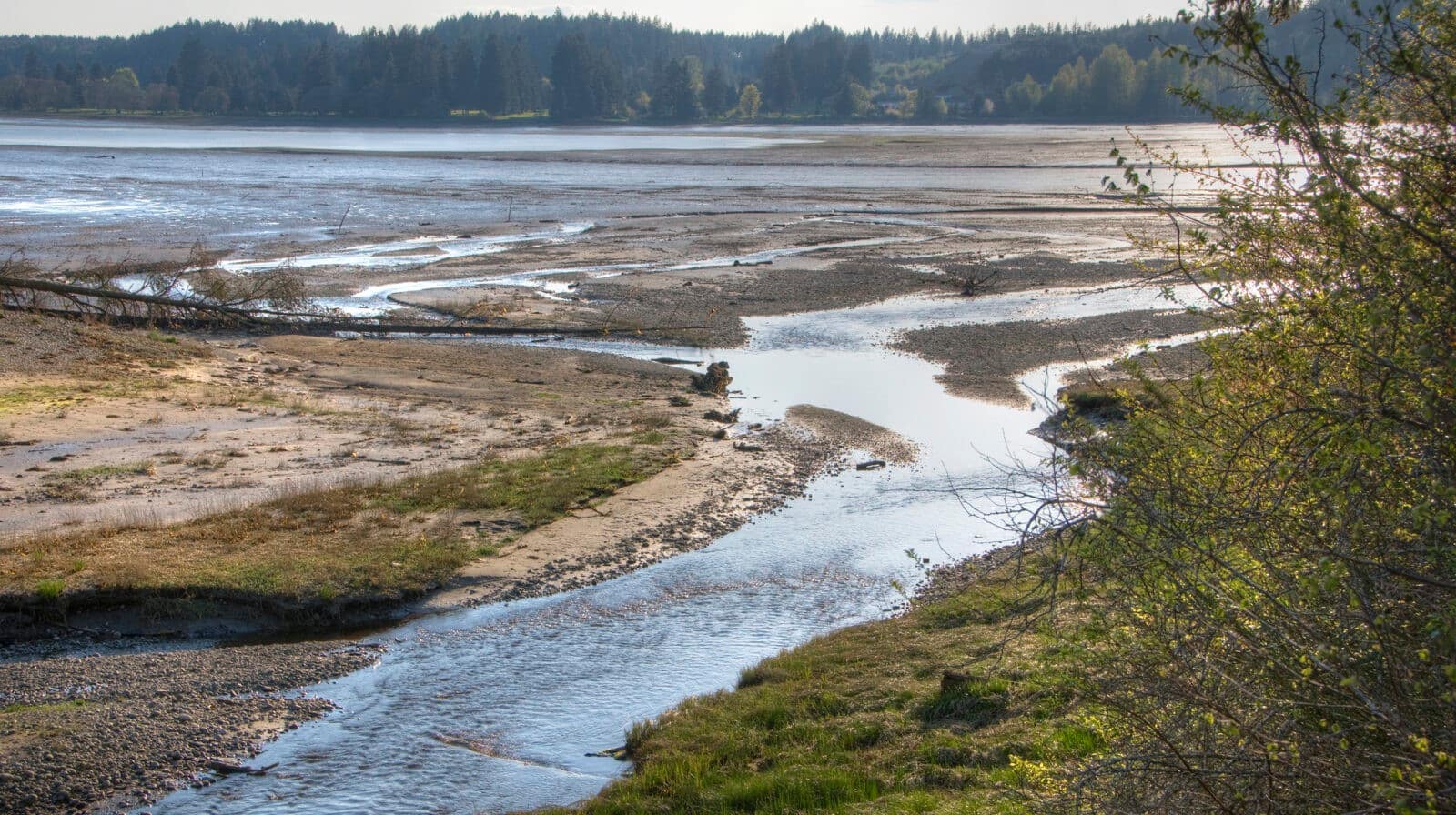
  • 83 acres and half a mile of shoreline on Oakland Bay, northeast of Shelton near the Twin Rivers Ranch Preserve in Mason County.
  • Oakland Bay County Park provides habitat for Bald Eagles, deer, great blue heron, crustaceans, countless shorebirds, raccoons, possibly bear, and certainly salmonids.
  • The property features salt marshes, mudflats, forested uplands, a salmon-bearing stream, and is one of the few Land Trust properties with public access.

Visit the Park:

Location: 1570 E Agate Bay Rd, Shelton
Directions: Head south on E Agate Rd from Hwy 3. Park entrance is on your right 1/2 mile past Pioneer School (across from E Julian Rd).
Open: Year round, daylight hours

Thank you to the following partners:

  • Mason County Parks
  • Phyllis Bridge
  • The Nature Conservancy
  • Squaxin Island Tribe
  • Washington Wildlife and Recreation Coalition

CLT Strategic Conservation Goals Achieved:

  • Conserve wetlands, riparian areas, and associate upland forests.
  • Conserve marine shorelines and estuaries.

Notes From the Field: Salmon Sanctuary on Oakland Bay

by Shelley Kirk Rudeen (Issue 42, June 2005)

In one of the far corners of Puget Sound, a creek flows cold and the color of tea.It brings a breath of cool air from the forest to tideflats shimmering in late spring heat. This estuary, where the fresh water of Malaney Creek mixes with Oakland Bay’s salt water, is the centerpiece of a new conservation acquisition northeast of Shelton. The acquisition protects three quarters of a mile of the creek, forested estuary, eighty acres of forest and meadow, and two thousand feet of forested marine shoreline on Oakland Bay.

Three years in the crafting – this project was a team effort between Capitol Land Trust, Mason County, and the Salmon Recovery Funding Board. The Squaxin Island Tribe, the South Puget Sound Salmon Enhancement Group, and the Southwest Puget Sound Watershed Council also provided important support and assistance. Capitol Land Trust negotiated to purchase the land from longtime owner Phyllis Birge with funds from the Salmon Recovery Funding Board and funding from Mason County. The land is now owned by the people of Mason County while the Trust holds a permanent conservation easement, allowing it to provide stewardship and management of the land.

The reason for all the fuss will become evident next autumn. It will be raining then, the kind of rain that swells the creek and sends its unique scent into the bay, signaling home to chum and coho salmon returning from the northern Pacific Ocean. The salmon will surge upstream to spawn in gravel washed by cool, clear water. Cutthroat trout and steelhead will hang in the riffles and pools, waiting for the chance to snack on drifting eggs. Otters, mink, birds and other animals will feast on the carcasses of spawned-out salmon. As they wander away from their meals, the animals will leave their scat in the surrounding forest. In this way, nutrients that the salmon brought from the ocean will become available to Douglas fir, salal, and wild rose.

While salmon eggs incubate through the winter, a lesser known story will unfold. At high tide, small “forage fish” – surf smelt and sand lance – will deposit their tiny eggs in shallow water among sand and fine gravel on the beach. The eggs will hatch into larvae that drift among the plankton, gradually growing and transforming into their adult forms. These fish feed the masses: larval sand lance are a significant part of the diet of juvenile salmon, while adult forms of both fish nourish marine mammals, seabirds, and other fishes. This forested shoreline is important to forage fish and their place in the food web because it does not have bulkheads. Bulkheads tend to reflect the energy of waves back to the beach, scouring away spawning sediments.

In spring a new chapter opens in the story, as young salmon emerge from the gravels of Malaney Creek. Coho fry will stay in the creek for another year, while the chum move downstream and into the bay. For a few weeks they’ll drift with the tides – seeking deep water when the tide is out and moving shoreward with the rising tide, perhaps using the shadows of fallen trees to hide from herons and kingfishers. As the tide slips into patches of saltmarsh along the shore and the mouth of the creek, the little chum will swim among pickleweed and arrowgrass, feeding on microscopic organisms. Soon they will be ready for their journey to the ocean.

The health of Puget Sound depends on places like this where the natural processes of forest, shoreline, and creek are allowed to unfold with minimal interruption. It’s the kind of place where life begins: you can see it in the burgeoning spring growth of the forest, and in the arcing flight of swallows and wood pewees hunting insects above the estuary for their young broods. It’s also a place where life comes full circle, as when the salmon return to spawn and die. On this day you can see it overhead, too, in the elegant patience of vultures, wheeling in the blue.

  • Facebook
  • Instragram
  • Youtube

  • PO Box 14065
  • Tumwater, WA 98511
  • Telephone: (360) 943-3012
  • Email:

  • Who We Are
  • Our Mission
  • Board & Staff
  • Collaboration
  • Financials
  • Library
  • Careers
  • Get Involved
  • Trail Steward
  • Stewardship Work Parties
  • Salmon Docent
  • K-12 Outdoor Programs
  • Ways To Give
  • Cash
  • Other Ways to Give
  • Become a Business Partner
  • Gifts of Land
  • Bequests, Estate Plans & Wills
  • Stocks, Donor Advised Funds, IRAs
  • Conserved Lands
  • Conservation Map
  • Conserving Key Habitats
  • Conservation Areas
  • Conserve Your Land
  • Visit A Preserve
  • Inspiring Kids Preserve
  • Managing Our Preserves
  • Donate
  • Contact
  • Events
  • News

Copyright © Capitol Land Trust All Rights Reserved. | Made by SlowClouds