• Donate
  • Contact
  • Facebook
  • Instagram
  • YouTube
menu
  • Visit A Preserve
  • Who We Are
    • Our Mission
    • Board & Staff
    • Collaboration
    • Financials
    • Library
  • Get Involved
    • Trail Steward
    • Salmon Docent
    • Stewardship Work Parties
    • K-12 Outdoor Programs
  • Ways To Give
    • Cash
    • Stocks, Donor Advised Funds, IRAs
    • Bequests, Estate Plans & Wills
    • Gifts of Land
    • Other Ways to Give
    • Become a Business Partner
  • Conserved Lands
    • Conservation Map
    • Conserving Key Habitats
    • Conservation Areas
      • Budd & Henderson Inlets
        • Bayfield Resource Co. Forest Conservation Easement
        • Bayfield Resource Co. Gull Harbor Conservation Easement
        • Brown Preserve
        • Cushman Conservation Easement
        • Hale Preserve
        • Harmony Farm Preserve
        • Howe Conservation Easement
        • Lonseth Preserve
        • Scheidt-Mayer Conservation Easement
        • Stephens Preserve
        • Woodland Creek
      • Black River / Chehalis Watershed
        • Aldridge Conservation Easement
        • Baretich Conservation Easement
        • Bergquist Conservation Easement
        • Black River Conservation Easement and Preserve
        • Darlin Creek Preserve
        • Davis Conservation Easement
        • Decker Creek Wetland Complex
        • DeFelice Preserve
        • Edwards Conservation Easement
        • Gordon Farm Conservation Easement
        • Heertje Conservation Easement
        • Holm-Rader Farm Conservation Easement
        • Leitner Prairie Conservation Easements
        • Tilley Wetlands Preserve
        • West Rocky Prairie
      • Cowlitz Watershed
        • Cowlitz River Preserve
      • Deschutes Watershed
        • Anderson Preserve
        • Bentley Conservation Easement
        • Bush Prairie Farm Conservation Easement
        • Parsons Family Farm Conservation Easement
        • Shermer-Deschutes Preserve
        • Springer Lake Preserve
        • Spurgeon Valley Preserve
        • Stewart Conservation Easement
        • Stewart-Deschutes Preserve
        • Yale Preserve
      • Green Cove Creek Wetlands
        • Harper Conservation Easement
        • Kaiser Preserve
        • LOTT Alliance Conservation Easement
        • Ekar-Overhulse Preserve
        • Paul-Leigh Conservation Easement
        • SPSCC Foundation Property
        • YWCA
      • Hood Canal
        • Brothers Beach Conservation Easement
      • Oakland Bay & Goldsborough Creek Watershed
        • Bayshore Preserve
        • Granquist Preserve
        • Hilburn Preserve
        • North Fork Goldsborough Creek Preserve
        • Oakland Bay Historical Park Conservation Easement
        • Olli Conservation Easement
        • Pannell Preserve
        • Rose Preserve
        • North Fork Goldsborough Creek Preserve – Rose Addition
        • Sunset Bluffs
        • Twin Rivers Ranch Preserve
      • Steamboat Conservation Partnership Region
        • Adams Cove Preserve
        • Appleby Conservation Easement
        • Davidson-Bergman Conservation Easement
        • Lower Eld Preserve
        • McIntyre Conservation Easement
        • McLane Point Preserve/Conservation Easement
        • Randall Preserve / Allison Springs
        • Schmidt Conservation Easements
        • Triple Creek Farm Conservation Easement
        • Willits Conservation Easement
        • Willits Tree Farm Conservation Easement
        • Wynne Tree Farm Conservation Easements
    • Inspiring Kids Preserve
    • Conserve Your Land
    • Managing Our Preserves
  • News
  • Events
  • Donate
  • Contact
  • Visit A Preserve
  • Who We Are
    • Our Mission
    • Board & Staff
    • Collaboration
    • Financials
    • Library
  • Get Involved
    • Trail Steward
    • Salmon Docent
    • Stewardship Work Parties
    • K-12 Outdoor Programs
  • Ways To Give
    • Cash
    • Stocks, Donor Advised Funds, IRAs
    • Bequests, Estate Plans & Wills
    • Gifts of Land
    • Other Ways to Give
    • Become a Business Partner
  • Conserved Lands
    • Conservation Map
    • Conserving Key Habitats
    • Conservation Areas
      • Budd & Henderson Inlets
        • Bayfield Resource Co. Forest Conservation Easement
        • Bayfield Resource Co. Gull Harbor Conservation Easement
        • Brown Preserve
        • Cushman Conservation Easement
        • Hale Preserve
        • Harmony Farm Preserve
        • Howe Conservation Easement
        • Lonseth Preserve
        • Scheidt-Mayer Conservation Easement
        • Stephens Preserve
        • Woodland Creek
      • Black River / Chehalis Watershed
        • Aldridge Conservation Easement
        • Baretich Conservation Easement
        • Bergquist Conservation Easement
        • Black River Conservation Easement and Preserve
        • Darlin Creek Preserve
        • Davis Conservation Easement
        • Decker Creek Wetland Complex
        • DeFelice Preserve
        • Edwards Conservation Easement
        • Gordon Farm Conservation Easement
        • Heertje Conservation Easement
        • Holm-Rader Farm Conservation Easement
        • Leitner Prairie Conservation Easements
        • Tilley Wetlands Preserve
        • West Rocky Prairie
      • Cowlitz Watershed
        • Cowlitz River Preserve
      • Deschutes Watershed
        • Anderson Preserve
        • Bentley Conservation Easement
        • Bush Prairie Farm Conservation Easement
        • Parsons Family Farm Conservation Easement
        • Shermer-Deschutes Preserve
        • Springer Lake Preserve
        • Spurgeon Valley Preserve
        • Stewart Conservation Easement
        • Stewart-Deschutes Preserve
        • Yale Preserve
      • Green Cove Creek Wetlands
        • Harper Conservation Easement
        • Kaiser Preserve
        • LOTT Alliance Conservation Easement
        • Ekar-Overhulse Preserve
        • Paul-Leigh Conservation Easement
        • SPSCC Foundation Property
        • YWCA
      • Hood Canal
        • Brothers Beach Conservation Easement
      • Oakland Bay & Goldsborough Creek Watershed
        • Bayshore Preserve
        • Granquist Preserve
        • Hilburn Preserve
        • North Fork Goldsborough Creek Preserve
        • Oakland Bay Historical Park Conservation Easement
        • Olli Conservation Easement
        • Pannell Preserve
        • Rose Preserve
        • North Fork Goldsborough Creek Preserve – Rose Addition
        • Sunset Bluffs
        • Twin Rivers Ranch Preserve
      • Steamboat Conservation Partnership Region
        • Adams Cove Preserve
        • Appleby Conservation Easement
        • Davidson-Bergman Conservation Easement
        • Lower Eld Preserve
        • McIntyre Conservation Easement
        • McLane Point Preserve/Conservation Easement
        • Randall Preserve / Allison Springs
        • Schmidt Conservation Easements
        • Triple Creek Farm Conservation Easement
        • Willits Conservation Easement
        • Willits Tree Farm Conservation Easement
        • Wynne Tree Farm Conservation Easements
    • Inspiring Kids Preserve
    • Conserve Your Land
    • Managing Our Preserves
  • News
  • Events

Conserving Key Habitats

CameraPhoto by Mike Melton

  • ShareShare this post on Facebook
  • Share this post on FacebookTweet
Land Trust Accreditation Commission
Donate Today

Learn More About Us

  • Conserved Lands
  • Conservation Map
  • Conserving Key Habitats
  • Conservation Areas
  • Conserve Your Land
  • Visit A Preserve
  • Inspiring Kids Preserve
  • Managing Our Preserves

Because we live in a rapidly growing part of the country, we now risk losing essential habitats that will affect our quality of life forever. This closing window of opportunity demands that we work together to ensure the character of our region into the future. Our focus is to protect three major habitat types – marine shorelines and estuaries; rivers, wetlands, and the forests around them; and oak woodlands and prairies – along with working farms, forests and ranches. .

Marine Shorelines and Estuaries

Puget Sound is the second largest estuarine system in the United States. The South Sound’s estuaries are transition zones where freshwater rivers and streams mix with salt water. Estuaries filter pollutants and improve water quality.

Acre for acre, estuaries are among the most biologically productive ecosystems on earth. Many species of birds, mammals, fish, and other animals and plants rely on estuarine habitats to live, feed, and reproduce. They also support commercial and recreational shellfish production, and provide an essential aspect of South Sound’s iconic natural beauty.

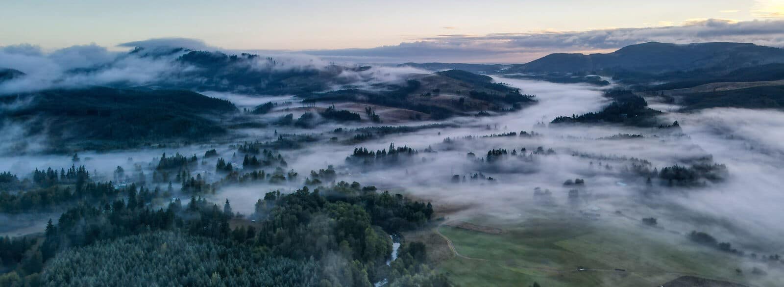
Wetlands, Riparian Areas, and Associated Upland Forests

Wetlands provide habitat for hundreds of species of waterfowl and many other migratory and resident birds, as well as for fish, amphibians, mammals, insects, and an array of plant species. Wetlands reduce the impacts of flooding and erosion by slowing and absorbing storm-water runoff. Wetlands also can filter out sediments and pollutants and help provide clean water to streams and aquifers.

Riparian areas form strips of land that border creeks and rivers. Healthy, functioning riparian areas and connected forests stabilize soils, filter out sediment and pollution, reduce runoff, improve water quality and reduce stream temperatures. They also provide habitat and food for 80% of our region’s fish and wildlife.

Prairies and Oak Woodlands

10,000 years ago, retreating glaciers helped form an expanse of prairie and oak savannahs across a significant area of the southern Puget Sound lowland region. Prairie plants and flowers sustained Native Americans who occupied the area for centuries before settlers arrived.

Home to many unique plant and wildlife species, native prairies are among the most endangered ecological communities in North America, and in southern Puget Sound only 2-3% of the original prairies and oak woodlands remain.

Working Lands

Southwest Washington’s extensive farms, ranches, and timberlands provide important economic and conservation benefits. These working lands contribute millions of dollars to local economies by producing commodities and providing jobs and a sustained income base.

Working lands often contain important wildlife habitat and other conservation values; and buffer and connect protected lands nearby. Often it is more beneficial for working lands to stay in production rather than be converted to other uses — a key concern in the face of economic pressure for more intensive development.

By working cooperatively with private landowners to place conservation easements on working lands, we help keep those lands productive and viable; support local business and the rural character of our region; and protect wildlife habitat, watershed functions and open space.

View a map of all our conserved lands

  • Facebook
  • Instragram
  • Youtube

  • PO Box 14065
  • Tumwater, WA 98511
  • Telephone: (360) 943-3012
  • Email:

  • Who We Are
  • Our Mission
  • Board & Staff
  • Collaboration
  • Financials
  • Library
  • Careers
  • Get Involved
  • Trail Steward
  • Stewardship Work Parties
  • Salmon Docent
  • K-12 Outdoor Programs
  • Ways To Give
  • Cash
  • Other Ways to Give
  • Become a Business Partner
  • Gifts of Land
  • Bequests, Estate Plans & Wills
  • Stocks, Donor Advised Funds, IRAs
  • Conserved Lands
  • Conservation Map
  • Conserving Key Habitats
  • Conservation Areas
  • Conserve Your Land
  • Visit A Preserve
  • Inspiring Kids Preserve
  • Managing Our Preserves
  • Donate
  • Contact
  • Events
  • News

Copyright © Capitol Land Trust All Rights Reserved. | Made by SlowClouds