• Donate
  • Contact
  • Facebook
  • Instagram
  • YouTube
menu
  • Visit A Preserve
  • Who We Are
    • Our Mission
    • Board & Staff
    • Collaboration
    • Financials
    • Library
  • Get Involved
    • Trail Steward
    • Salmon Docent
    • Stewardship Work Parties
    • K-12 Outdoor Programs
  • Ways To Give
    • Cash
    • Stocks, Donor Advised Funds, IRAs
    • Bequests, Estate Plans & Wills
    • Gifts of Land
    • Other Ways to Give
    • Become a Business Partner
  • Conserved Lands
    • Conservation Map
    • Conserving Key Habitats
    • Conservation Areas
      • Budd & Henderson Inlets
        • Bayfield Resource Co. Forest Conservation Easement
        • Bayfield Resource Co. Gull Harbor Conservation Easement
        • Brown Preserve
        • Cushman Conservation Easement
        • Hale Preserve
        • Harmony Farm Preserve
        • Howe Conservation Easement
        • Lonseth Preserve
        • Scheidt-Mayer Conservation Easement
        • Stephens Preserve
        • Woodland Creek
      • Black River / Chehalis Watershed
        • Aldridge Conservation Easement
        • Baretich Conservation Easement
        • Bergquist Conservation Easement
        • Black River Conservation Easement and Preserve
        • Darlin Creek Preserve
        • Davis Conservation Easement
        • Decker Creek Wetland Complex
        • DeFelice Preserve
        • Edwards Conservation Easement
        • Gordon Farm Conservation Easement
        • Heertje Conservation Easement
        • Holm-Rader Farm Conservation Easement
        • Leitner Prairie Conservation Easements
        • Tilley Wetlands Preserve
        • West Rocky Prairie
      • Cowlitz Watershed
        • Cowlitz River Preserve
      • Deschutes Watershed
        • Anderson Preserve
        • Bentley Conservation Easement
        • Bush Prairie Farm Conservation Easement
        • Parsons Family Farm Conservation Easement
        • Shermer-Deschutes Preserve
        • Springer Lake Preserve
        • Spurgeon Valley Preserve
        • Stewart Conservation Easement
        • Stewart-Deschutes Preserve
        • Yale Preserve
      • Green Cove Creek Wetlands
        • Harper Conservation Easement
        • Kaiser Preserve
        • LOTT Alliance Conservation Easement
        • Ekar-Overhulse Preserve
        • Paul-Leigh Conservation Easement
        • SPSCC Foundation Property
        • YWCA
      • Hood Canal
        • Brothers Beach Conservation Easement
      • Oakland Bay & Goldsborough Creek Watershed
        • Bayshore Preserve
        • Granquist Preserve
        • Hilburn Preserve
        • North Fork Goldsborough Creek Preserve
        • Oakland Bay Historical Park Conservation Easement
        • Olli Conservation Easement
        • Pannell Preserve
        • Rose Preserve
        • North Fork Goldsborough Creek Preserve – Rose Addition
        • Sunset Bluffs
        • Twin Rivers Ranch Preserve
      • Steamboat Conservation Partnership Region
        • Adams Cove Preserve
        • Appleby Conservation Easement
        • Davidson-Bergman Conservation Easement
        • Lower Eld Preserve
        • McIntyre Conservation Easement
        • McLane Point Preserve/Conservation Easement
        • Randall Preserve / Allison Springs
        • Schmidt Conservation Easements
        • Triple Creek Farm Conservation Easement
        • Willits Conservation Easement
        • Willits Tree Farm Conservation Easement
        • Wynne Tree Farm Conservation Easements
    • Inspiring Kids Preserve
    • Conserve Your Land
    • Managing Our Preserves
  • News
  • Events
  • Donate
  • Contact
  • Visit A Preserve
  • Who We Are
    • Our Mission
    • Board & Staff
    • Collaboration
    • Financials
    • Library
  • Get Involved
    • Trail Steward
    • Salmon Docent
    • Stewardship Work Parties
    • K-12 Outdoor Programs
  • Ways To Give
    • Cash
    • Stocks, Donor Advised Funds, IRAs
    • Bequests, Estate Plans & Wills
    • Gifts of Land
    • Other Ways to Give
    • Become a Business Partner
  • Conserved Lands
    • Conservation Map
    • Conserving Key Habitats
    • Conservation Areas
      • Budd & Henderson Inlets
        • Bayfield Resource Co. Forest Conservation Easement
        • Bayfield Resource Co. Gull Harbor Conservation Easement
        • Brown Preserve
        • Cushman Conservation Easement
        • Hale Preserve
        • Harmony Farm Preserve
        • Howe Conservation Easement
        • Lonseth Preserve
        • Scheidt-Mayer Conservation Easement
        • Stephens Preserve
        • Woodland Creek
      • Black River / Chehalis Watershed
        • Aldridge Conservation Easement
        • Baretich Conservation Easement
        • Bergquist Conservation Easement
        • Black River Conservation Easement and Preserve
        • Darlin Creek Preserve
        • Davis Conservation Easement
        • Decker Creek Wetland Complex
        • DeFelice Preserve
        • Edwards Conservation Easement
        • Gordon Farm Conservation Easement
        • Heertje Conservation Easement
        • Holm-Rader Farm Conservation Easement
        • Leitner Prairie Conservation Easements
        • Tilley Wetlands Preserve
        • West Rocky Prairie
      • Cowlitz Watershed
        • Cowlitz River Preserve
      • Deschutes Watershed
        • Anderson Preserve
        • Bentley Conservation Easement
        • Bush Prairie Farm Conservation Easement
        • Parsons Family Farm Conservation Easement
        • Shermer-Deschutes Preserve
        • Springer Lake Preserve
        • Spurgeon Valley Preserve
        • Stewart Conservation Easement
        • Stewart-Deschutes Preserve
        • Yale Preserve
      • Green Cove Creek Wetlands
        • Harper Conservation Easement
        • Kaiser Preserve
        • LOTT Alliance Conservation Easement
        • Ekar-Overhulse Preserve
        • Paul-Leigh Conservation Easement
        • SPSCC Foundation Property
        • YWCA
      • Hood Canal
        • Brothers Beach Conservation Easement
      • Oakland Bay & Goldsborough Creek Watershed
        • Bayshore Preserve
        • Granquist Preserve
        • Hilburn Preserve
        • North Fork Goldsborough Creek Preserve
        • Oakland Bay Historical Park Conservation Easement
        • Olli Conservation Easement
        • Pannell Preserve
        • Rose Preserve
        • North Fork Goldsborough Creek Preserve – Rose Addition
        • Sunset Bluffs
        • Twin Rivers Ranch Preserve
      • Steamboat Conservation Partnership Region
        • Adams Cove Preserve
        • Appleby Conservation Easement
        • Davidson-Bergman Conservation Easement
        • Lower Eld Preserve
        • McIntyre Conservation Easement
        • McLane Point Preserve/Conservation Easement
        • Randall Preserve / Allison Springs
        • Schmidt Conservation Easements
        • Triple Creek Farm Conservation Easement
        • Willits Conservation Easement
        • Willits Tree Farm Conservation Easement
        • Wynne Tree Farm Conservation Easements
    • Inspiring Kids Preserve
    • Conserve Your Land
    • Managing Our Preserves
  • News
  • Events

News Story
January 3, 2023

Meyer’s Point – A Partnership for Conservation and Education

CameraForest and shoreline at Meyer's Point Conservation Easement, Mike Melton

  • ShareShare this post on Facebook
  • Share this post on FacebookTweet
Land Trust Accreditation Commission
Donate Today

Learn More About Us

  • Conserved Lands
  • Conservation Map
  • Conserving Key Habitats
  • Conservation Areas
  • Conserve Your Land
  • Visit A Preserve
  • Inspiring Kids Preserve
  • Managing Our Preserves

A significant portion of Puget Sound shoreline will be permanently conserved, providing environmental research and education opportunities to the entire region, thanks to a new partnership between Capitol Land Trust (CLT), Washington State University (WSU), and affiliated groups, including the Squaxin Island Tribe.

The land trust has purchased a permanent conservation easement on 94 acres of land, known as Meyer’s Point Environmental Field Station, owned by WSU on the western shore of Henderson Inlet. The majority of the funding for the easement comes from grants from the National Coastal Wetlands Conservation Grant Program and the Washington State Recreation and Conservation Office. The easement allows for the maintenance of WSU’s existing facilities, plus the development of up to 20 upland acres for teaching, research, and outreach. Development of the rest of the property is limited by the conservation easement to maintain the wildlife habitat values.

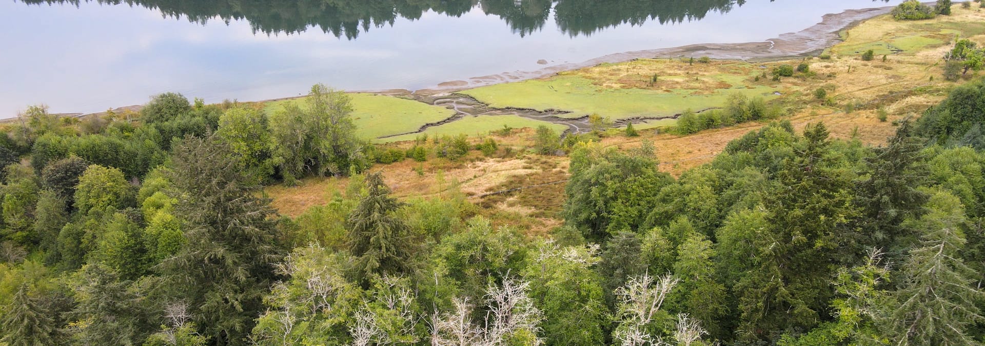
Meyer’s Point Conservation Easement shoreline, Mike Melton.

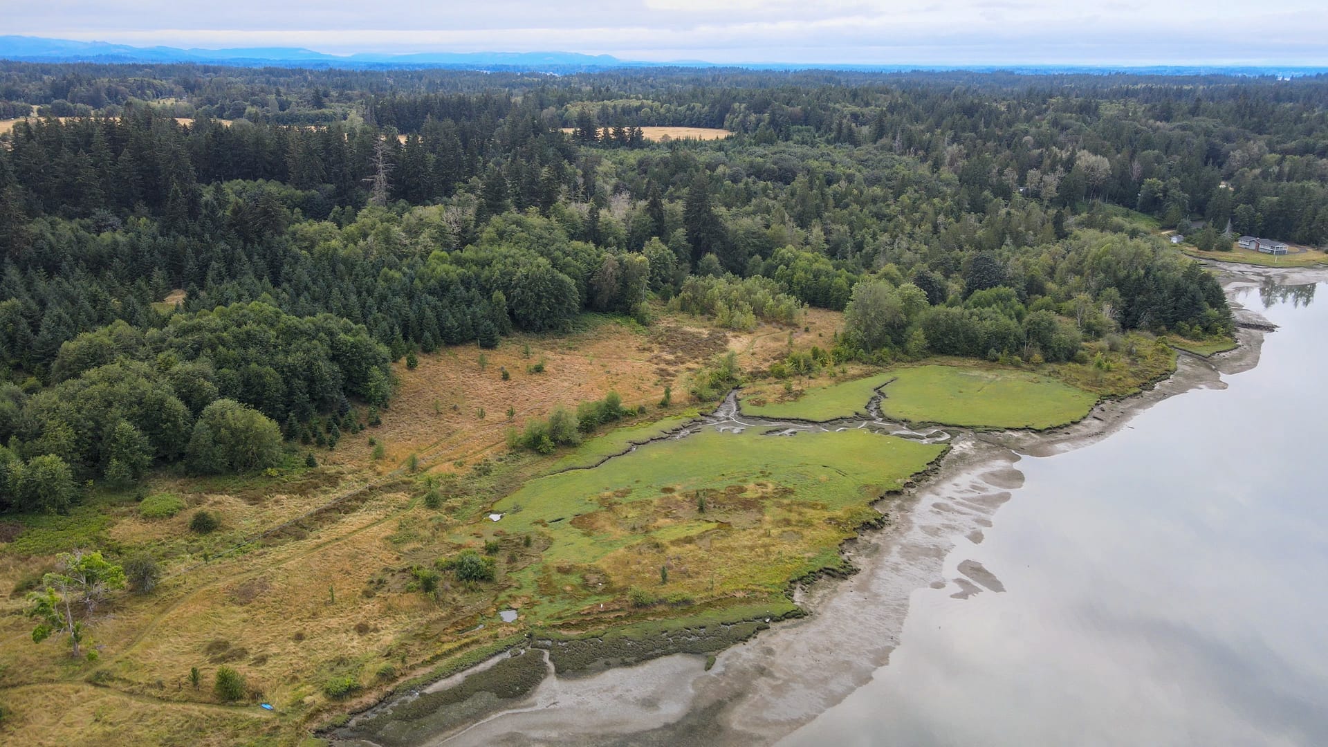
The property includes multiple wildlife habitats, from estuary and nearshore habitat to an agricultural field and forest stands ranging from 15 to 70 years old. It also includes 43.6 acres of wetlands, 3,600 feet of Meyer’s Creek, and 2,100 feet of unarmored marine shoreline. It is adjacent to Woodard Bay Natural Resources Conservation Area and across the inlet from more than 150 acres of land owned and managed by CLT for conservation and environmental education opportunities for local students.

“This new partnership will provide additional resources to further advance WSU’s vision of a teaching, research and outreach facility at the Meyer’s Point Environmental Field Station, where students and scientists can incorporate the extensive nearshore, wetland and upland forested habitats into outdoor learning and research projects,” said Stephen Bollens, director of the field station and WSU professor of biological and environmental sciences.

Henderson Inlet is in the southern reaches of the Salish Sea, northwest of Olympia. It was named after James Henderson, quartermaster of the 1841 Charles Wilkes exploration expedition. The inlet is also known as Noo-She-Chatl in indigenous communities who have made the area their home since time immemorial.

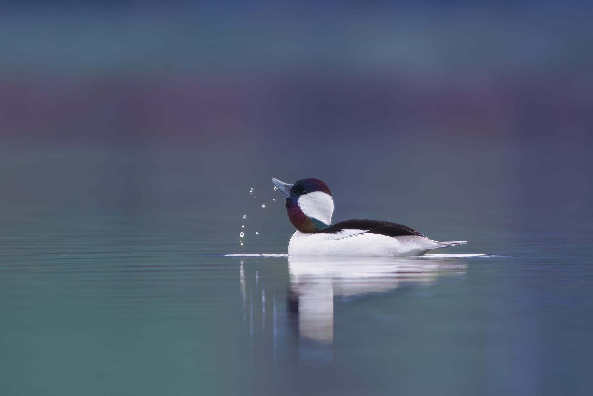
The inlet is a highly productive estuary that provides protected saltwater habitat for young fish, including chinook, steelhead, and coho, as they adjust from the freshwater of the streams where they were born. It also supplies abundant food and shelter for many migratory and resident bird species such as buffleheads, surf scoters and American widgeons. At low tide the mudflats of the inlet are rich in food for migrating and resident shorebirds, including great blue herons, long-billed dowitchers and a variety of sandpipers. Eagles, osprey, mink, the native Olympia oyster, and harbor seals along with many other species benefit from the aquatic and upland the area supports.

Bufflehead, Garrett Yarter.

“Our 5-year Strategic Plan guides us to focus on priority landscapes where we can be most effective, so we concentrate our efforts to protect South Puget Sound estuaries, wetlands, prairies, forestlands, and farms. We prioritize lands for protection that are adjacent to or close to lands that are already managed for their conservation values as a way of compounding the benefit to wildlife. Conserving Meyer’s Point is an important step in preserving natural places contributing to our exceptional quality of life in the South Puget Sound region today and into the future,” said Dave Winter, Executive Director at Capitol Land Trust.

Capitol Land Trust and the Squaxin Island Tribe have a formal agreement to work jointly on coastal conservation efforts and the Tribe provided support for this project with scientific and mapping services. Taylor Shellfish Farms also contributed financial support to encourage coastal protection and environmental educational efforts across the Puget Sound region. Along with the purchase of the conservation easement, CLT staff and volunteers will join with WSU and Olympia High School’s Earth Corps to control non-native invasive plants, like English ivy, and perform other habitat restoration activities. The goal is to expand an existing long-term partnership that provides education on the importance of removing invasive vegetation and the benefits of habitat restoration and land conservation in general.

Areas of land outlined on a map. Meyer's Point is outlined in yellow to the south of Woodard Bay Conservation Area. Four other properties are outlined in green an represent other areas conserved by CLT.
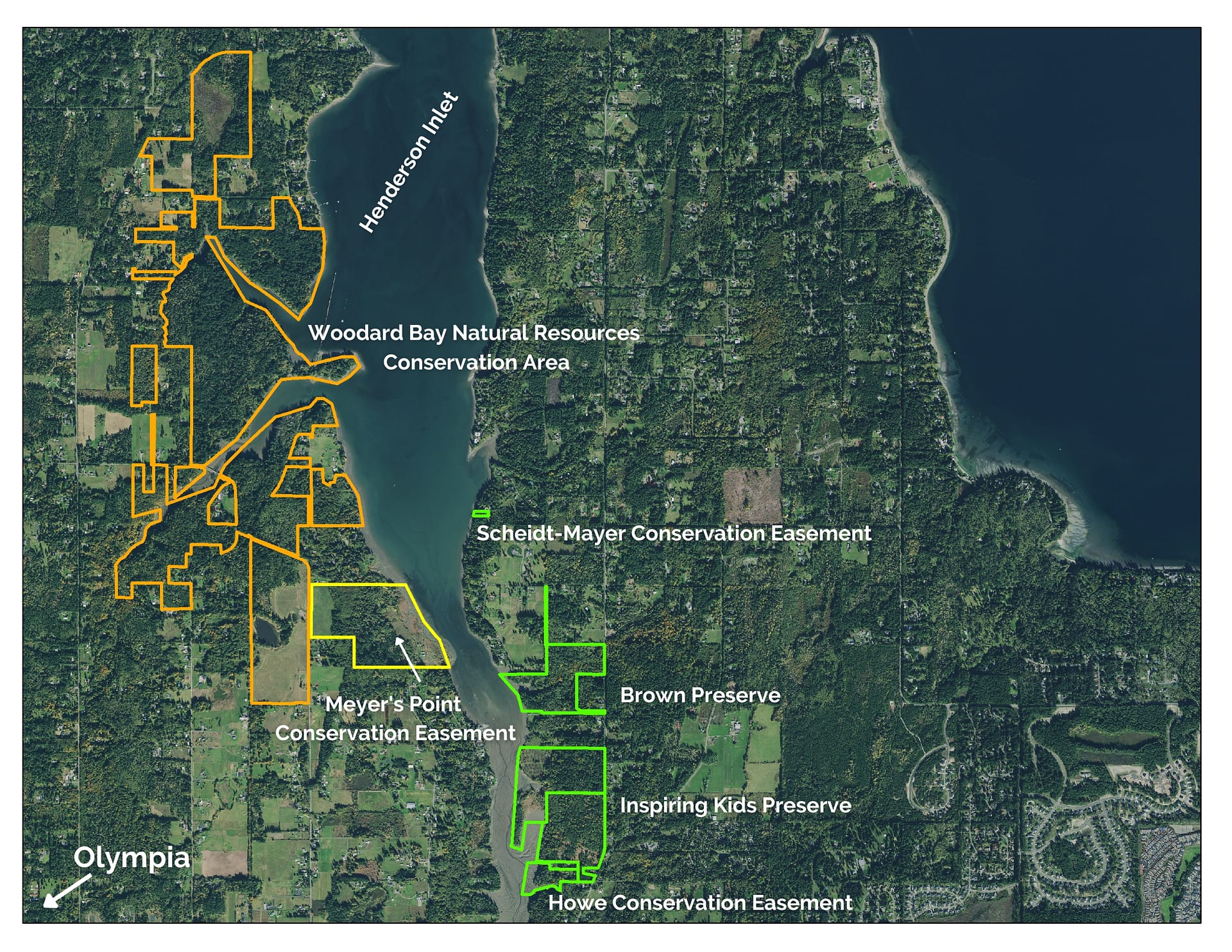
A map showing conserved lands in Henderson Inlet. Meyer’s Point Conservation Easement outlined in yellow.

“The field station’s efforts will remain focused on three thematic areas: water science; the interface between agriculture and ecosystems; and ‘people and place’ in the arts, humanities and sciences,” Bollens said.

“Higher education is at its best when we connect our research and teaching directly with the people and places we serve, and there are few places better suited to do that shared work than Meyer’s Point,” said Todd Butler, dean of the WSU College of Arts and Sciences. “We share Capitol Land Trust’s commitment to this special place. Preserving Meyer’s Point isn’t just about removing a significant piece of land from the pressures of modern development—it’s also about preserving opportunities for this generation and the next to study, teach and learn, and, in doing so, to help address some of the world’s greatest contemporary challenges.”

  • Facebook
  • Instragram
  • Youtube

  • PO Box 14065
  • Tumwater, WA 98511
  • Telephone: (360) 943-3012
  • Email:

  • Who We Are
  • Our Mission
  • Board & Staff
  • Collaboration
  • Financials
  • Library
  • Careers
  • Get Involved
  • Trail Steward
  • Stewardship Work Parties
  • Salmon Docent
  • K-12 Outdoor Programs
  • Ways To Give
  • Cash
  • Other Ways to Give
  • Become a Business Partner
  • Gifts of Land
  • Bequests, Estate Plans & Wills
  • Stocks, Donor Advised Funds, IRAs
  • Conserved Lands
  • Conservation Map
  • Conserving Key Habitats
  • Conservation Areas
  • Conserve Your Land
  • Visit A Preserve
  • Inspiring Kids Preserve
  • Managing Our Preserves
  • Donate
  • Contact
  • Events
  • News

Copyright © Capitol Land Trust All Rights Reserved. | Made by SlowClouds