• Donate
  • Contact
  • Facebook
  • Instagram
  • YouTube
menu
  • Visit A Preserve
  • Who We Are
    • Our Mission
    • Board & Staff
    • Collaboration
    • Financials
    • Library
  • Get Involved
    • Trail Steward
    • Salmon Docent
    • Stewardship Work Parties
    • K-12 Outdoor Programs
  • Ways To Give
    • Cash
    • Stocks, Donor Advised Funds, IRAs
    • Bequests, Estate Plans & Wills
    • Gifts of Land
    • Other Ways to Give
    • Become a Business Partner
  • Conserved Lands
    • Conservation Map
    • Conserving Key Habitats
    • Conservation Areas
      • Budd & Henderson Inlets
        • Bayfield Resource Co. Forest Conservation Easement
        • Bayfield Resource Co. Gull Harbor Conservation Easement
        • Brown Preserve
        • Cushman Conservation Easement
        • Hale Preserve
        • Harmony Farm Preserve
        • Howe Conservation Easement
        • Lonseth Preserve
        • Scheidt-Mayer Conservation Easement
        • Stephens Preserve
        • Woodland Creek
      • Black River / Chehalis Watershed
        • Aldridge Conservation Easement
        • Baretich Conservation Easement
        • Bergquist Conservation Easement
        • Black River Conservation Easement and Preserve
        • Darlin Creek Preserve
        • Davis Conservation Easement
        • Decker Creek Wetland Complex
        • DeFelice Preserve
        • Edwards Conservation Easement
        • Gordon Farm Conservation Easement
        • Heertje Conservation Easement
        • Holm-Rader Farm Conservation Easement
        • Leitner Prairie Conservation Easements
        • Tilley Wetlands Preserve
        • West Rocky Prairie
      • Cowlitz Watershed
        • Cowlitz River Preserve
      • Deschutes Watershed
        • Anderson Preserve
        • Bentley Conservation Easement
        • Bush Prairie Farm Conservation Easement
        • Parsons Family Farm Conservation Easement
        • Shermer-Deschutes Preserve
        • Springer Lake Preserve
        • Spurgeon Valley Preserve
        • Stewart Conservation Easement
        • Stewart-Deschutes Preserve
        • Yale Preserve
      • Green Cove Creek Wetlands
        • Harper Conservation Easement
        • Kaiser Preserve
        • LOTT Alliance Conservation Easement
        • Ekar-Overhulse Preserve
        • Paul-Leigh Conservation Easement
        • SPSCC Foundation Property
        • YWCA
      • Hood Canal
        • Brothers Beach Conservation Easement
      • Oakland Bay & Goldsborough Creek Watershed
        • Bayshore Preserve
        • Granquist Preserve
        • Hilburn Preserve
        • North Fork Goldsborough Creek Preserve
        • Oakland Bay Historical Park Conservation Easement
        • Olli Conservation Easement
        • Pannell Preserve
        • Rose Preserve
        • North Fork Goldsborough Creek Preserve – Rose Addition
        • Sunset Bluffs
        • Twin Rivers Ranch Preserve
      • Steamboat Conservation Partnership Region
        • Adams Cove Preserve
        • Appleby Conservation Easement
        • Davidson-Bergman Conservation Easement
        • Lower Eld Preserve
        • McIntyre Conservation Easement
        • McLane Point Preserve/Conservation Easement
        • Randall Preserve / Allison Springs
        • Schmidt Conservation Easements
        • Triple Creek Farm Conservation Easement
        • Willits Conservation Easement
        • Willits Tree Farm Conservation Easement
        • Wynne Tree Farm Conservation Easements
    • Inspiring Kids Preserve
    • Conserve Your Land
    • Managing Our Preserves
  • News
  • Events
  • Donate
  • Contact
  • Visit A Preserve
  • Who We Are
    • Our Mission
    • Board & Staff
    • Collaboration
    • Financials
    • Library
  • Get Involved
    • Trail Steward
    • Salmon Docent
    • Stewardship Work Parties
    • K-12 Outdoor Programs
  • Ways To Give
    • Cash
    • Stocks, Donor Advised Funds, IRAs
    • Bequests, Estate Plans & Wills
    • Gifts of Land
    • Other Ways to Give
    • Become a Business Partner
  • Conserved Lands
    • Conservation Map
    • Conserving Key Habitats
    • Conservation Areas
      • Budd & Henderson Inlets
        • Bayfield Resource Co. Forest Conservation Easement
        • Bayfield Resource Co. Gull Harbor Conservation Easement
        • Brown Preserve
        • Cushman Conservation Easement
        • Hale Preserve
        • Harmony Farm Preserve
        • Howe Conservation Easement
        • Lonseth Preserve
        • Scheidt-Mayer Conservation Easement
        • Stephens Preserve
        • Woodland Creek
      • Black River / Chehalis Watershed
        • Aldridge Conservation Easement
        • Baretich Conservation Easement
        • Bergquist Conservation Easement
        • Black River Conservation Easement and Preserve
        • Darlin Creek Preserve
        • Davis Conservation Easement
        • Decker Creek Wetland Complex
        • DeFelice Preserve
        • Edwards Conservation Easement
        • Gordon Farm Conservation Easement
        • Heertje Conservation Easement
        • Holm-Rader Farm Conservation Easement
        • Leitner Prairie Conservation Easements
        • Tilley Wetlands Preserve
        • West Rocky Prairie
      • Cowlitz Watershed
        • Cowlitz River Preserve
      • Deschutes Watershed
        • Anderson Preserve
        • Bentley Conservation Easement
        • Bush Prairie Farm Conservation Easement
        • Parsons Family Farm Conservation Easement
        • Shermer-Deschutes Preserve
        • Springer Lake Preserve
        • Spurgeon Valley Preserve
        • Stewart Conservation Easement
        • Stewart-Deschutes Preserve
        • Yale Preserve
      • Green Cove Creek Wetlands
        • Harper Conservation Easement
        • Kaiser Preserve
        • LOTT Alliance Conservation Easement
        • Ekar-Overhulse Preserve
        • Paul-Leigh Conservation Easement
        • SPSCC Foundation Property
        • YWCA
      • Hood Canal
        • Brothers Beach Conservation Easement
      • Oakland Bay & Goldsborough Creek Watershed
        • Bayshore Preserve
        • Granquist Preserve
        • Hilburn Preserve
        • North Fork Goldsborough Creek Preserve
        • Oakland Bay Historical Park Conservation Easement
        • Olli Conservation Easement
        • Pannell Preserve
        • Rose Preserve
        • North Fork Goldsborough Creek Preserve – Rose Addition
        • Sunset Bluffs
        • Twin Rivers Ranch Preserve
      • Steamboat Conservation Partnership Region
        • Adams Cove Preserve
        • Appleby Conservation Easement
        • Davidson-Bergman Conservation Easement
        • Lower Eld Preserve
        • McIntyre Conservation Easement
        • McLane Point Preserve/Conservation Easement
        • Randall Preserve / Allison Springs
        • Schmidt Conservation Easements
        • Triple Creek Farm Conservation Easement
        • Willits Conservation Easement
        • Willits Tree Farm Conservation Easement
        • Wynne Tree Farm Conservation Easements
    • Inspiring Kids Preserve
    • Conserve Your Land
    • Managing Our Preserves
  • News
  • Events

News
October 29, 2018

Restoring a Forest Using Wood Chips

Restoration with wood chips

Camera Restoration can take a lot of wood chips. But how do we move it all?

  • ShareShare this post on Facebook
  • Share this post on FacebookTweet
Land Trust Accreditation Commission
Donate Today

Learn More About Us

  • Conserved Lands
  • Conservation Map
  • Conserving Key Habitats
  • Conservation Areas
  • Conserve Your Land
  • Visit A Preserve
  • Inspiring Kids Preserve
  • Managing Our Preserves

Have you ever visited one of Capitol Land Trust’s (CLT) restoration sites? Have you helped us plant? If you have then you likely have seen large piles of wood chips. These massive piles can dwarf a person and could bury CLT’s pickup truck. But somehow these massive piles of wood chips need to be placed around each and every plant… *gulp*

Luckily, we have started to use a new technique (new for us) that makes moving wood chips so much easier. But before we dive into that let’s look at why CLT uses wood chips in our restoration work.

If you want to learn more about Capitol Land Trust’s restoration and stewardship work in the South Puget Sound sign up for our monthly email newsletter.

Looking Down to See the Forest

Look down to see the forest

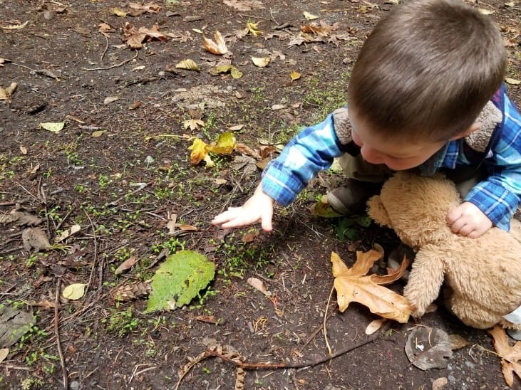
My son has no problem looking down to explore the forest floor at Capitol Land Trust’s future Inspiring Kids Preserve. Credit: Daron Williams

When you think of a forest what do you think of first? The trees? I would be shocked if you gave me a different answer. I mean how can something be a forest without the trees?!

But in many ways the trees are just the tip of this evergreen iceberg. What we see – the trees – is just a small part of what makes a forest a forest.

Let me ask you a question. How do trees affect the area where they grow?

You might say they cast shade. Or they add a vertical element to the relatively flat ground. Trees also drop leaves, branches, needles, etc. onto the forest floor.

But it does not stop there.

Trees also send roots out through the soil, drawing in nutrients and water. The trees also release water through their needles or leaves. And all those leaves, branches, etc. that fall to the forest floor help to return nutrients to the soil.

In some areas, trees are the largest source of water in the atmosphere. By pumping water from the ground up into the air, trees can literally change the weather.

All of these interactions – and much more that I just don’t have time to cover – between trees and the land around them is ultimately what makes a forest a forest.

In the cool, moist duff on the forest floor (all the small branches, leaves and other natural litter of the forest), the soil is dominated by fungi that interconnect the various trees and other plants in a vast network that has been called the wood wide web in the media and in scientific journals.

Other small life thrive in this environment found on the forest floor.

Now think about a grassland.

The roots of the grass likely cover a smaller area but are much denser than the roots of a tree. More light reaches the ground and there is less large pieces of woody material like branches.

All of this means that grasslands tend to be drier and hotter environments than forests in the same general area. The soils are also dominated by bacteria instead of fungi.

Using Wood Chips to Create a Forest

Using wood chips to create a forest

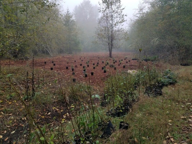
New planting out at Darlin Creek Preserve using wood chips to start creating a forest.

So, what does this all have to do with wood chips?

Well I would argue that it is the forest floor, more than the trees that define a forest. The forest floor does not exist without the trees, but a forest is not a forest without a forest floor.

The difference is between a savannah (think open forest with grasses growing between the trees) and our deep, dark forests. Just because you have trees does not mean you have a forest.

That is where wood chips come in.

When you are trying to restore a forest, you will often just think about planting trees. But as you now know, trees are not enough to make a forest.

This is why you need to add wood chips around the new trees. The wood chips mimic all of those leaves, branches, needles, etc. that fall from the trees in a forest.

The wood chips cool the soil, provide homes for small critters and provide habitat for fungi to grow. The more wood chips you can put down the better the result.

Shifting from Spot Mulching to Island Mulching

Use wood chips and forest islands for restoration

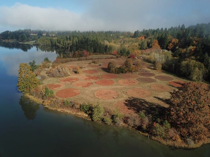
Restoring a forest using forest islands/clusters instead of planting in a grid.

This is why CLT is now planting in clusters, or “islands” instead of the classic grid pattern. When you plant your trees in a grid you often only place mulch around each tree – spot mulching. But when you plant in clusters or islands you can mulch the entire cluster.

You can also mulch the island/cluster before you plant which is much easier.

This starts to quickly transform the land from an open grassland to a forest. The trees still need to grow and fill in the canopy, but the mulch helps to get the process started.

Mulching these large areas also helps to reduce water loss to evaporation and minimizes the presence of plants we don’t want like non-native grasses.

This is why we call these clusters “islands” – they are forest islands in a sea of grass.

Moving the Mulch

I’m sure by this point you are thinking – that may all be true but moving that much mulch is still a pain in the you know what.

Which is why CLT is shifting to a new method to make moving mulch much, much, easier.

In the past CLT has relied on volunteers to move hundreds of loads of wood chips by wheelbarrow from the big pile out to the plants that needed the mulch.

If you have helped us do that I want to send you a huge thank you! Your hard work made those events possible.

But, as awesome as all of you volunteers are there is a limit to what you all can complete. You can only move mulch so fast. Plus, we don’t want to wear you out – we have plants to plant too!

That brings us to our new method for moving mulch.

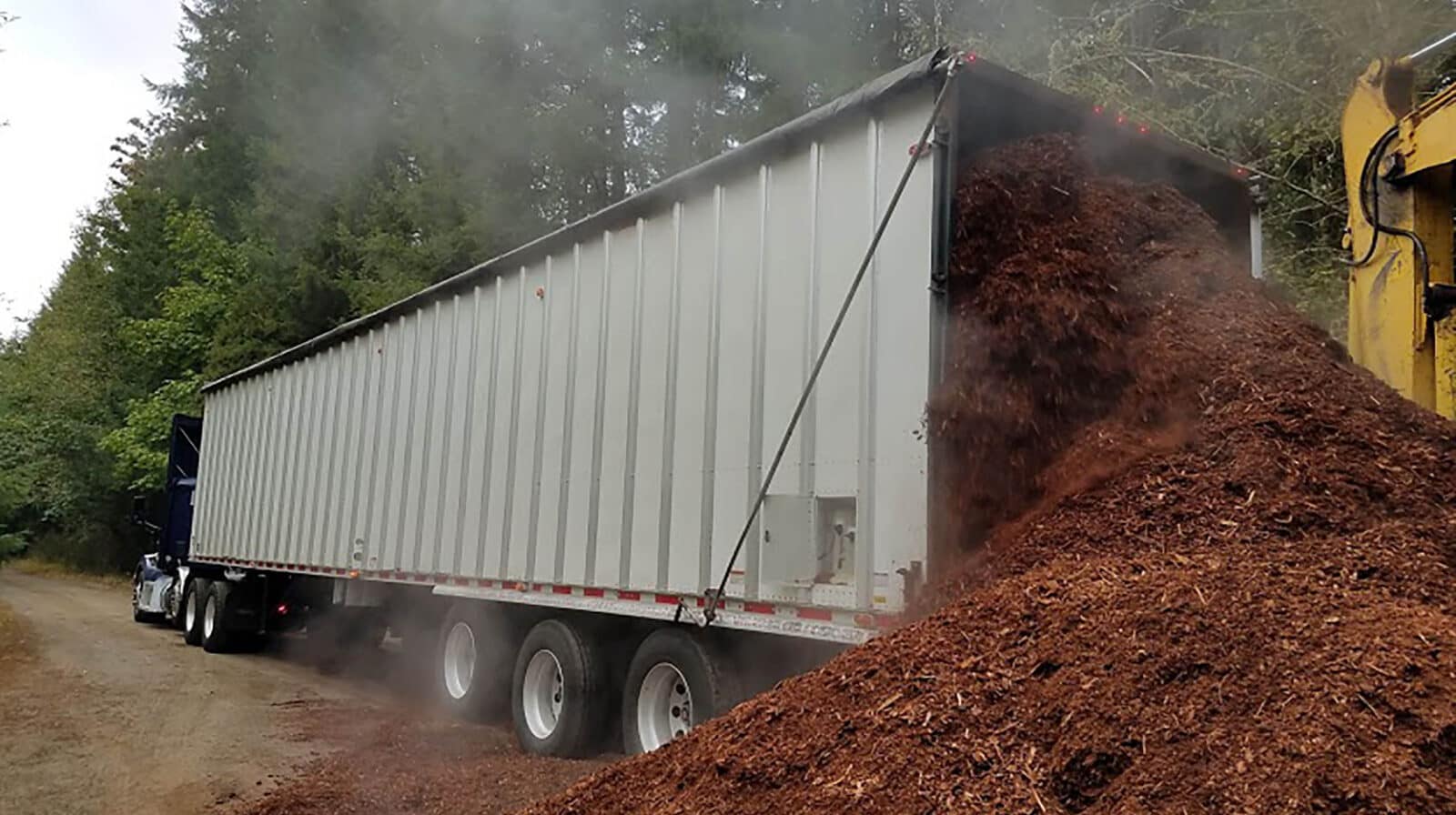
If you have been out to Darlin Creek Preserve, then you may have seen these large areas that have recently been mulched. Around 1.3 acres were mulched with approximately 480 cubic yards of mulch.

That much mulch would fill approximately 40 dump trucks!

Now what if I told you it only took us 2 days to spread all that mulch? And nope, it did not take hundreds of volunteers to make that happen.

Instead we used for the first time a mulch blowing truck. This truck was loaded by an excavator and then another person was able to spread all the mulch with a third person working the blowing truck.

Just 3 people to spread over 480 cubic yards of mulch in just 2 days!

But what about all of you who want to volunteer and help CLT restore the forests?

Well we have been working with Native Plant Salvage Foundation to run a series of awesome volunteer events focused not on mulching but instead planting native plants in the mulched areas.

Breaking the work up like this is more efficient, more effective, and I think more fun.

Future Restoration and Restoration at Your Home

Forest floor restoration with wood chips

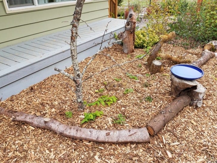
A small in progress restoration project in front of my front door that mimics the forest floor. Credit: Daron Williams

Moving forward CLT will be planting more and more in clusters/islands and less in grids. The clusters/islands will be fully mulched and then planted. This will greatly improve our restoration projects and make them much more successful.

But this is also a new method and we are learning the best way to use it. Future clusters might be a little bit smaller, so it only takes one truck load of mulch to cover each one.

We may experiment with adding large woody debris to these islands to further mimic the structure of a forest – think fallen logs.

But what about you and your own backyard/land?

You can use this method too, just at a smaller scale. Pick out an area that you want to plant native plants.

If there is a lot of existing plants there like grass, place cardboard down first and cover that all with wood chips. Do this in April or May and let it sit until the fall.

By this point the cardboard will have mostly decomposed and you can plant your native plants. Just make sure to move the mulch aside so your new plant is planted in the soil not in the mulch. Then push the mulch back around the plant but leave a few inches of space between the mulch and the trunk/stem of the plant.

The result will be a beautiful patch of native plants that will support local wildlife like the birds we all love.

Here is a video from WSU College of Agricultural, Human and Natural Resource Sciences on how to plant native plants.

Thanks for reading and make sure to check out our weekly stewardship/restoration events. We could not do the work we do without help from people like you.

Don’t forget to sign up for our monthly email newsletter to hear more about Capitol Land Trust’s restoration and stewardship programs.

I hope you have enjoyed this post – please don’t hesitate to reach out to me with any questions.

Daron Williams
Capitol Land Trust – Restoration and Public Access Manager


  • Facebook
  • Instragram
  • Youtube

  • PO Box 14065
  • Tumwater, WA 98511
  • Telephone: (360) 943-3012
  • Email:

  • Who We Are
  • Our Mission
  • Board & Staff
  • Collaboration
  • Financials
  • Library
  • Careers
  • Get Involved
  • Trail Steward
  • Stewardship Work Parties
  • Salmon Docent
  • K-12 Outdoor Programs
  • Ways To Give
  • Cash
  • Other Ways to Give
  • Become a Business Partner
  • Gifts of Land
  • Bequests, Estate Plans & Wills
  • Stocks, Donor Advised Funds, IRAs
  • Conserved Lands
  • Conservation Map
  • Conserving Key Habitats
  • Conservation Areas
  • Conserve Your Land
  • Visit A Preserve
  • Inspiring Kids Preserve
  • Managing Our Preserves
  • Donate
  • Contact
  • Events
  • News

Copyright © Capitol Land Trust All Rights Reserved. | Made by SlowClouds