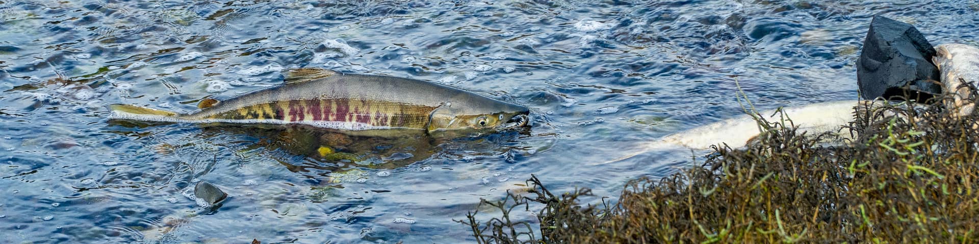
Every fall, thousands of chum salmon return from the Pacific Ocean to Johns Creek, completing one of nature’s most extraordinary journeys. This November, Capitol Land Trust (CLT) and Puget Sound Estuarium invite you to experience this remarkable migration firsthand during our annual Salmon Experience at Bayshore Preserve.
Join us on Saturday, November 8, Sunday, November 9, and Tuesday, November 11 2025, from 10:00 am – 2:00 pm, to witness salmon fighting their way upstream to spawn where their lives began. Knowledgeable salmon docents will be on-site to answer questions about salmon behavior, life cycles, and about the habitat restoration efforts at Bayshore Preserve. Underwater cameras will also offer a unique look at the action below the surface.
This free, family-friendly program is a chance to connect with local wildlife and learn about the importance of healthy habitats. Don’t forget to bring polarized glasses—they’ll help you see salmon more clearly through the water.
Details at a Glance
Saturday, November 8, Sunday, November 9, and Tuesday, November 11
10:00 am – 2:00 pm
Bayshore Preserve, 3800 WA-3, Shelton, WA 98584
Saturday, November 8
- Kids activities with the Shelton Timberland Library and local author Mary Boone, 10:00 am – 2:00 pm
- Bird outing with South Sound Bird Alliance, 10:30 am (meet at the welcoming plaza)
Sunday, November 9
- Bird outing with South Sound Bird Alliance, 10:30 am (meet at the welcoming plaza)
Tuesday, November 11
- Bird outing with South Sound Bird Alliance, 10:30 am (meet at the welcoming plaza)
Our conserved public access preserves provide opportunities year-round to enjoy the outdoors, but the salmon run at Bayshore Preserve is especially unforgettable. Come share in this seasons tradition and create memories in nature that will last a lifetime.
Questions? Contact Capitol Land Trust at 360.943.3012 or [email protected].
Frequently Asked Questions
Yes! Knowledgeable salmon docents will be at Bayshore Preserve during Salmon Experience hours to help you understand what’s happening in the creek, from salmon life cycles and migration patterns to how habitat restoration supports their return. Look for their bright orange or green vests.
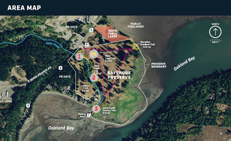
The best viewing areas are along Johns Creek at the pedestrian bridge and at the estuary. These areas are marked 1, 2, and 3 on the map below. Docents will be stationed in these areas to help you spot salmon and explain their behavior. Underwater cameras will also provide a unique view of the salmon below the surface and a spotting scope will be available at station 3. Visit each station to see the salmon at different point along their migration from the estuary. If you are visiting on a day when no docents are present, you can take the trail map with you on your phone and learn more about the preserve during your visit using our self-guided interpretive Google Map. Using polarized glasses will help you see salmon in the water.
The trail from the parking lot to the bridge is a gentle 5% grade or less and is surfaced with crushed rock. A crushed rock trail also extends along a portion of Johns Creek, offering smoother access to key salmon viewing areas. The main viewing area is relatively flat and close to parking. There is also an ADA compliant parking space and portable toilet.
Trails at Bayshore Preserve are mostly gravel and crushed rock, with gentle slopes. Visitors using mobility aids may find uneven or muddy surfaces in some areas the further into the preserve you go.
Address: 3800 WA-3, Shelton, WA 98584. Look for event signage along the highway. Volunteers will be on site to help direct parking and guide you to the salmon viewing areas.
Do not turn onto Bayshore Drive, there is no access to the preserve. Bayshore Preserve’s parking lot is immediately off Highway 3 across from the Shell gas station.
Transit Options: Mason County Transit route 1 and Dial-A-Ride. (There is not a marked bus stop at Bayshore Preserve, so you will need to communicate with the bus driver where you are going and flag them down for your return trip.)
No. Parking at Bayshore Preserve is free. On Salmon Experience days overflow parking will be available. Please note that overflow parking is only available for Salmon Experience from 10:00 am – 2:00 pm on November 8, 9, and 11. For additional parking, drive north along Highway 3 to the Washington Department of Fish & Wildlife’s parking lot, located here. Please note that a Discover Pass is needed for this lot.
We recommend you leave your dogs at home when experiencing the salmon run. Not only do we see a peak number of visitors during this time, but also fatal diseases can be passed from fish carcasses to dogs. Should your dog become sick after having contact with a fish carcass consult a veterinarian immediately.
During other times of the year dogs are welcome at the preserve and must be kept on a leash for the safety of people and wildlife.