• Donate
  • Contact
  • Facebook
  • Instagram
  • YouTube
menu
  • Visit A Preserve
  • Who We Are
    • Our Mission
    • Board & Staff
    • Collaboration
    • Financials
    • Library
  • Get Involved
    • Trail Steward
    • Salmon Docent
    • Stewardship Work Parties
    • K-12 Outdoor Programs
  • Ways To Give
    • Cash
    • Stocks, Donor Advised Funds, IRAs
    • Bequests, Estate Plans & Wills
    • Gifts of Land
    • Other Ways to Give
    • Become a Business Partner
  • Conserved Lands
    • Conservation Map
    • Conserving Key Habitats
    • Conservation Areas
      • Budd & Henderson Inlets
        • Bayfield Resource Co. Forest Conservation Easement
        • Bayfield Resource Co. Gull Harbor Conservation Easement
        • Brown Preserve
        • Cushman Conservation Easement
        • Hale Preserve
        • Harmony Farm Preserve
        • Howe Conservation Easement
        • Lonseth Preserve
        • Scheidt-Mayer Conservation Easement
        • Stephens Preserve
        • Woodland Creek
      • Black River / Chehalis Watershed
        • Aldridge Conservation Easement
        • Baretich Conservation Easement
        • Bergquist Conservation Easement
        • Black River Conservation Easement and Preserve
        • Darlin Creek Preserve
        • Davis Conservation Easement
        • Decker Creek Wetland Complex
        • DeFelice Preserve
        • Edwards Conservation Easement
        • Gordon Farm Conservation Easement
        • Heertje Conservation Easement
        • Holm-Rader Farm Conservation Easement
        • Leitner Prairie Conservation Easements
        • Tilley Wetlands Preserve
        • West Rocky Prairie
      • Cowlitz Watershed
        • Cowlitz River Preserve
      • Deschutes Watershed
        • Anderson Preserve
        • Bentley Conservation Easement
        • Bush Prairie Farm Conservation Easement
        • Parsons Family Farm Conservation Easement
        • Shermer-Deschutes Preserve
        • Springer Lake Preserve
        • Spurgeon Valley Preserve
        • Stewart Conservation Easement
        • Stewart-Deschutes Preserve
        • Yale Preserve
      • Green Cove Creek Wetlands
        • Harper Conservation Easement
        • Kaiser Preserve
        • LOTT Alliance Conservation Easement
        • Ekar-Overhulse Preserve
        • Paul-Leigh Conservation Easement
        • SPSCC Foundation Property
        • YWCA
      • Hood Canal
        • Brothers Beach Conservation Easement
      • Oakland Bay & Goldsborough Creek Watershed
        • Bayshore Preserve
        • Granquist Preserve
        • Hilburn Preserve
        • North Fork Goldsborough Creek Preserve
        • Oakland Bay Historical Park Conservation Easement
        • Olli Conservation Easement
        • Pannell Preserve
        • Rose Preserve
        • North Fork Goldsborough Creek Preserve – Rose Addition
        • Sunset Bluffs
        • Twin Rivers Ranch Preserve
      • Steamboat Conservation Partnership Region
        • Adams Cove Preserve
        • Appleby Conservation Easement
        • Davidson-Bergman Conservation Easement
        • Lower Eld Preserve
        • McIntyre Conservation Easement
        • McLane Point Preserve/Conservation Easement
        • Randall Preserve / Allison Springs
        • Schmidt Conservation Easements
        • Triple Creek Farm Conservation Easement
        • Willits Conservation Easement
        • Willits Tree Farm Conservation Easement
        • Wynne Tree Farm Conservation Easements
    • Inspiring Kids Preserve
    • Conserve Your Land
    • Managing Our Preserves
  • News
  • Events
  • Donate
  • Contact
  • Visit A Preserve
  • Who We Are
    • Our Mission
    • Board & Staff
    • Collaboration
    • Financials
    • Library
  • Get Involved
    • Trail Steward
    • Salmon Docent
    • Stewardship Work Parties
    • K-12 Outdoor Programs
  • Ways To Give
    • Cash
    • Stocks, Donor Advised Funds, IRAs
    • Bequests, Estate Plans & Wills
    • Gifts of Land
    • Other Ways to Give
    • Become a Business Partner
  • Conserved Lands
    • Conservation Map
    • Conserving Key Habitats
    • Conservation Areas
      • Budd & Henderson Inlets
        • Bayfield Resource Co. Forest Conservation Easement
        • Bayfield Resource Co. Gull Harbor Conservation Easement
        • Brown Preserve
        • Cushman Conservation Easement
        • Hale Preserve
        • Harmony Farm Preserve
        • Howe Conservation Easement
        • Lonseth Preserve
        • Scheidt-Mayer Conservation Easement
        • Stephens Preserve
        • Woodland Creek
      • Black River / Chehalis Watershed
        • Aldridge Conservation Easement
        • Baretich Conservation Easement
        • Bergquist Conservation Easement
        • Black River Conservation Easement and Preserve
        • Darlin Creek Preserve
        • Davis Conservation Easement
        • Decker Creek Wetland Complex
        • DeFelice Preserve
        • Edwards Conservation Easement
        • Gordon Farm Conservation Easement
        • Heertje Conservation Easement
        • Holm-Rader Farm Conservation Easement
        • Leitner Prairie Conservation Easements
        • Tilley Wetlands Preserve
        • West Rocky Prairie
      • Cowlitz Watershed
        • Cowlitz River Preserve
      • Deschutes Watershed
        • Anderson Preserve
        • Bentley Conservation Easement
        • Bush Prairie Farm Conservation Easement
        • Parsons Family Farm Conservation Easement
        • Shermer-Deschutes Preserve
        • Springer Lake Preserve
        • Spurgeon Valley Preserve
        • Stewart Conservation Easement
        • Stewart-Deschutes Preserve
        • Yale Preserve
      • Green Cove Creek Wetlands
        • Harper Conservation Easement
        • Kaiser Preserve
        • LOTT Alliance Conservation Easement
        • Ekar-Overhulse Preserve
        • Paul-Leigh Conservation Easement
        • SPSCC Foundation Property
        • YWCA
      • Hood Canal
        • Brothers Beach Conservation Easement
      • Oakland Bay & Goldsborough Creek Watershed
        • Bayshore Preserve
        • Granquist Preserve
        • Hilburn Preserve
        • North Fork Goldsborough Creek Preserve
        • Oakland Bay Historical Park Conservation Easement
        • Olli Conservation Easement
        • Pannell Preserve
        • Rose Preserve
        • North Fork Goldsborough Creek Preserve – Rose Addition
        • Sunset Bluffs
        • Twin Rivers Ranch Preserve
      • Steamboat Conservation Partnership Region
        • Adams Cove Preserve
        • Appleby Conservation Easement
        • Davidson-Bergman Conservation Easement
        • Lower Eld Preserve
        • McIntyre Conservation Easement
        • McLane Point Preserve/Conservation Easement
        • Randall Preserve / Allison Springs
        • Schmidt Conservation Easements
        • Triple Creek Farm Conservation Easement
        • Willits Conservation Easement
        • Willits Tree Farm Conservation Easement
        • Wynne Tree Farm Conservation Easements
    • Inspiring Kids Preserve
    • Conserve Your Land
    • Managing Our Preserves
  • News
  • Events

News
August 11, 2020

Success! 74 acres conserved on the Skookumchuck River!

CameraMueller Conservation Easement, Mike Melton

  • ShareShare this post on Facebook
  • Share this post on FacebookTweet
Land Trust Accreditation Commission
Donate Today

Learn More About Us

  • Conserved Lands
  • Conservation Map
  • Conserving Key Habitats
  • Conservation Areas
  • Conserve Your Land
  • Visit A Preserve
  • Inspiring Kids Preserve
  • Managing Our Preserves

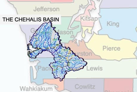
Expansive is one word to describe the second largest watershed in Washington State: the Chehalis River Basin. Shaped like an askew moth, the tip of one wing reaches 5,000 feet in elevation to drain south out of the Olympic mountains. The other wing drains to the west from the Deschutes River, and towards the north, draining Willapa Hills. The Chehalis River watershed sprawls over 2,600 square miles, with 11 sub-basins bringing together 3,300 miles of streams and rivers.

Chehalis River Basin, Chehalis Basin Fisheries Task Force.

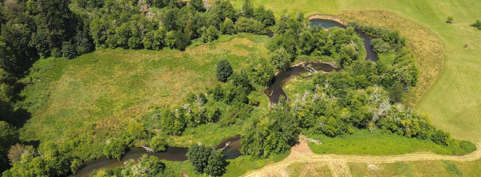
One of these rivers is the Skookumchuck River, which flows into the mainstem of the Chehalis River in Centralia shortly after passing through Riverside Park. About 19 miles upstream from Centralia, the Skookumchuck does a quick zig-zag just below the Skookumchuck Reservoir.

The zig zagging Skookumchuck River, Mike Melton.

The land along this zig-zag is owned by Geoff and Lorna Mueller. The Muellers moved to Skookumchuck Valley in 2017 because growing up, Lorna had spent a lot of time in the valley visiting her grandparents, and she had always wanted to return. They enjoy the quiet and watch the river change from year to year as rivers do. They’ve also noticed the change to the valley over the years, as farmland is converted to housing.

Looking for a way to reduce the upkeep on their land, the Muellers decided to “hand the reins back to nature.” As a first step, they have placed a conservation easement on their land with Capitol Land Trust. A conservation easement is an agreement between a landowner and a land trust that permanently limits uses of the land in order to protect its conservation values. For the 74 acres the Muellers own, this agreement ensures that the property will never be subdivided or further developed.

“Good habitat conservation requires an environment with quality resources, or the ability to create quality resources, and opportunity,” said CLT Land Protection Manager Thom Woodruff. “Here, the Skookumchuck River provides the environment and the Muellers, and the other partners in this effort, provided the opportunity.”

Next, the Muellers are partnering with Thurston Conservation District and the Washington Department of Fish and Wildlife to improve this stretch of the Skookumchuck River. The partnership will work together to install large woody debris, improve floodplain connectivity, and replace invasive riparian vegetation with native species.

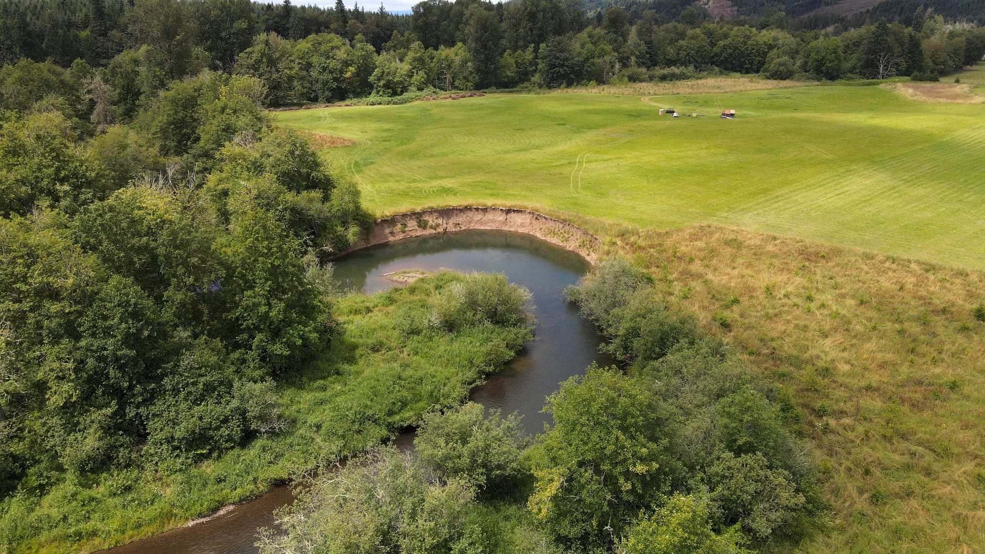
The surrounding area to be restored, Mike Melton.

The term “large woody debris” refers to the fallen trees, logs, and stumps, root wads, and piles of branches along the edges of a waterbody. These fallen wood pieces are a huge part of the stream ecosystem because the wood stabilizes the shoreline preventing excessive erosion and provides vital habitat for fish and other creatures.

Woody debris and vegetation shading a portion of the river, Mike Melton.

A healthy population of shoreline vegetation, or riparian vegetation, also supports aquatic animals by cooling the water temperature, providing nutrients, like bugs falling off leaves, and shelter to the life in the creek. The vegetation also improves water quality for all living things by filtering runoff from the surrounding land.

Some of the aquatic wildlife benefitting from this restoration project include spring and fall chinook salmon, coho salmon, and winter steelhead. Other animals like migratory songbirds and elk will also be happy with the positive changes.

“This project has been such a joy to work on, with an amazing team of folks all pitching in to make it happen. I’m so grateful to our landowner partners on this project, we wouldn’t be able to accomplish any of these restoration actions without them, and they have been such engaged, positive and thoughtful partners in this process. I’m always striving to connect landowners with the programs and services that are the best possible fit for their goals, and the ASRP was a perfect match for the Mueller family! After years of work planning and preparing, it’s so exciting to see it start to be implemented.”
– Mara Healy, Thurston Conservation District Habitat Specialist

Geoff sees what they’re doing with their property as just a drop in the bucket of what we need to be doing to care for the land so that it can take care of us. While he might be right in the grand scheme of things, we know local land conservation starts with passionate individuals like Geoff and Lorna Mueller. Each conservation success adds to the network of open spaces and wildlife corridors across our region.

If you’re interested in exploring the Chehalis River Basin more, the Chehalis Basin Partnership has put together this interactive website.

Watch this short video of the Mueller Conservation Easement:

Thank you to the following partners:

  • Geoffrey and Lorna Mueller
  • Forterra
  • Office of Chehalis Basin
  • Recreation & Conservation Office
  • Thurston Conservation District
  • WA Dept. of Fish and Wildlife
  • WA Dept. of Ecology
  • Facebook
  • Instragram
  • Youtube

  • PO Box 14065
  • Tumwater, WA 98511
  • Telephone: (360) 943-3012
  • Email:

  • Who We Are
  • Our Mission
  • Board & Staff
  • Collaboration
  • Financials
  • Library
  • Careers
  • Get Involved
  • Trail Steward
  • Stewardship Work Parties
  • Salmon Docent
  • K-12 Outdoor Programs
  • Ways To Give
  • Cash
  • Other Ways to Give
  • Become a Business Partner
  • Gifts of Land
  • Bequests, Estate Plans & Wills
  • Stocks, Donor Advised Funds, IRAs
  • Conserved Lands
  • Conservation Map
  • Conserving Key Habitats
  • Conservation Areas
  • Conserve Your Land
  • Visit A Preserve
  • Inspiring Kids Preserve
  • Managing Our Preserves
  • Donate
  • Contact
  • Events
  • News

Copyright © Capitol Land Trust All Rights Reserved. | Made by SlowClouds