• Donate
  • Contact
  • Facebook
  • Instagram
  • YouTube
menu
  • Visit A Preserve
    • Bayshore Construction Updates
  • Who We Are
    • Our Mission
    • Board & Staff
    • Collaboration
    • Financials
    • Library
  • Get Involved
    • Trail Steward
    • Salmon Docent
    • Stewardship Work Parties
    • K-12 Outdoor Programs
  • Ways To Give
    • Cash
    • Stocks, Donor Advised Funds, IRAs
    • Bequests, Estate Plans & Wills
    • Gifts of Land
    • Other Ways to Give
    • Become a Business Partner
  • Conserved Lands
    • Conservation Map
    • Conserving Key Habitats
    • Conservation Areas
      • Budd & Henderson Inlets
        • Bayfield Resource Co. Forest Conservation Easement
        • Bayfield Resource Co. Gull Harbor Conservation Easement
        • Brown Preserve
        • Cushman Conservation Easement
        • Hale Preserve
        • Harmony Farm Preserve
        • Howe Conservation Easement
        • Lonseth Preserve
        • Scheidt-Mayer Conservation Easement
        • Stephens Preserve
        • Woodland Creek
      • Black River / Chehalis Watershed
        • Aldridge Conservation Easement
        • Baretich Conservation Easement
        • Bergquist Conservation Easement
        • Black River Conservation Easement and Preserve
        • Darlin Creek Preserve
        • Davis Conservation Easement
        • Decker Creek Wetland Complex
        • DeFelice Preserve
        • Edwards Conservation Easement
        • Gordon Farm Conservation Easement
        • Heertje Conservation Easement
        • Holm-Rader Farm Conservation Easement
        • Leitner Prairie Conservation Easements
        • Tilley Wetlands Preserve
        • West Rocky Prairie
      • Cowlitz Watershed
        • Cowlitz River Preserve
      • Deschutes Watershed
        • Anderson Preserve
        • Bentley Conservation Easement
        • Bush Prairie Farm Conservation Easement
        • Parsons Family Farm Conservation Easement
        • Shermer-Deschutes Preserve
        • Springer Lake Preserve
        • Spurgeon Valley Preserve
        • Stewart Conservation Easement
        • Stewart-Deschutes Preserve
        • Yale Preserve
      • Green Cove Creek Wetlands
        • Harper Conservation Easement
        • Kaiser Preserve
        • LOTT Alliance Conservation Easement
        • Ekar-Overhulse Preserve
        • Paul-Leigh Conservation Easement
        • SPSCC Foundation Property
        • YWCA
      • Hood Canal
        • Brothers Beach Conservation Easement
      • Oakland Bay & Goldsborough Creek Watershed
        • Bayshore Preserve
        • Granquist Preserve
        • Hilburn Preserve
        • North Fork Goldsborough Creek Preserve
        • Oakland Bay Historical Park Conservation Easement
        • Olli Conservation Easement
        • Pannell Preserve
        • Rose Preserve
        • North Fork Goldsborough Creek Preserve – Rose Addition
        • Sunset Bluffs
        • Twin Rivers Ranch Preserve
      • Steamboat Conservation Partnership Region
        • Adams Cove Preserve
        • Appleby Conservation Easement
        • Davidson-Bergman Conservation Easement
        • Lower Eld Preserve
        • McIntyre Conservation Easement
        • McLane Point Preserve/Conservation Easement
        • Randall Preserve / Allison Springs
        • Schmidt Conservation Easements
        • Triple Creek Farm Conservation Easement
        • Willits Conservation Easement
        • Willits Tree Farm Conservation Easement
        • Wynne Tree Farm Conservation Easements
    • Inspiring Kids Preserve
    • Conserve Your Land
    • Managing Our Preserves
  • News
  • Events
  • Donate
  • Contact
  • Visit A Preserve
    • Bayshore Construction Updates
  • Who We Are
    • Our Mission
    • Board & Staff
    • Collaboration
    • Financials
    • Library
  • Get Involved
    • Trail Steward
    • Salmon Docent
    • Stewardship Work Parties
    • K-12 Outdoor Programs
  • Ways To Give
    • Cash
    • Stocks, Donor Advised Funds, IRAs
    • Bequests, Estate Plans & Wills
    • Gifts of Land
    • Other Ways to Give
    • Become a Business Partner
  • Conserved Lands
    • Conservation Map
    • Conserving Key Habitats
    • Conservation Areas
      • Budd & Henderson Inlets
        • Bayfield Resource Co. Forest Conservation Easement
        • Bayfield Resource Co. Gull Harbor Conservation Easement
        • Brown Preserve
        • Cushman Conservation Easement
        • Hale Preserve
        • Harmony Farm Preserve
        • Howe Conservation Easement
        • Lonseth Preserve
        • Scheidt-Mayer Conservation Easement
        • Stephens Preserve
        • Woodland Creek
      • Black River / Chehalis Watershed
        • Aldridge Conservation Easement
        • Baretich Conservation Easement
        • Bergquist Conservation Easement
        • Black River Conservation Easement and Preserve
        • Darlin Creek Preserve
        • Davis Conservation Easement
        • Decker Creek Wetland Complex
        • DeFelice Preserve
        • Edwards Conservation Easement
        • Gordon Farm Conservation Easement
        • Heertje Conservation Easement
        • Holm-Rader Farm Conservation Easement
        • Leitner Prairie Conservation Easements
        • Tilley Wetlands Preserve
        • West Rocky Prairie
      • Cowlitz Watershed
        • Cowlitz River Preserve
      • Deschutes Watershed
        • Anderson Preserve
        • Bentley Conservation Easement
        • Bush Prairie Farm Conservation Easement
        • Parsons Family Farm Conservation Easement
        • Shermer-Deschutes Preserve
        • Springer Lake Preserve
        • Spurgeon Valley Preserve
        • Stewart Conservation Easement
        • Stewart-Deschutes Preserve
        • Yale Preserve
      • Green Cove Creek Wetlands
        • Harper Conservation Easement
        • Kaiser Preserve
        • LOTT Alliance Conservation Easement
        • Ekar-Overhulse Preserve
        • Paul-Leigh Conservation Easement
        • SPSCC Foundation Property
        • YWCA
      • Hood Canal
        • Brothers Beach Conservation Easement
      • Oakland Bay & Goldsborough Creek Watershed
        • Bayshore Preserve
        • Granquist Preserve
        • Hilburn Preserve
        • North Fork Goldsborough Creek Preserve
        • Oakland Bay Historical Park Conservation Easement
        • Olli Conservation Easement
        • Pannell Preserve
        • Rose Preserve
        • North Fork Goldsborough Creek Preserve – Rose Addition
        • Sunset Bluffs
        • Twin Rivers Ranch Preserve
      • Steamboat Conservation Partnership Region
        • Adams Cove Preserve
        • Appleby Conservation Easement
        • Davidson-Bergman Conservation Easement
        • Lower Eld Preserve
        • McIntyre Conservation Easement
        • McLane Point Preserve/Conservation Easement
        • Randall Preserve / Allison Springs
        • Schmidt Conservation Easements
        • Triple Creek Farm Conservation Easement
        • Willits Conservation Easement
        • Willits Tree Farm Conservation Easement
        • Wynne Tree Farm Conservation Easements
    • Inspiring Kids Preserve
    • Conserve Your Land
    • Managing Our Preserves
  • News
  • Events

News
September 10, 2025

With a Little Help from Friends—the Jorgenson Conservation Easement

CameraTowering Douglas firs and lush understory plants form a thriving habitat at the newly protected Jorgenson Conservation Easement.

  • ShareShare this post on Facebook
  • Share this post on FacebookTweet
Land Trust Accreditation Commission
Donate Today

Learn More About Us

  • Conserved Lands
  • Conservation Map
  • Conserving Key Habitats
  • Conservation Areas
  • Conserve Your Land
  • Visit A Preserve
  • Inspiring Kids Preserve
  • Managing Our Preserves

10 more acres protected. 35 acres connected.

Capitol Land Trust (CLT) has permanently conserved the 10-acre Jorgenson Conservation Easement in Thurston County. This small but mighty parcel links together two other neighboring CLT-conserved properties, creating 35 contiguous acres of forest, wetland, and riparian habitat that will remain protected forever.

An Unexpected Welcome

A gray marine layer had crept in and settled over the Jorgenson Conservation Easement. The July morning air was cool, and the gray light gave the lush green forest a moody feel. We had just begun our tour of CLT’s latest conserved property, when a barred owl flew from the trees, swooped overhead, and landed on a hemlock branch nearby. It turned its head and stared down at us with its big, curious eyes.


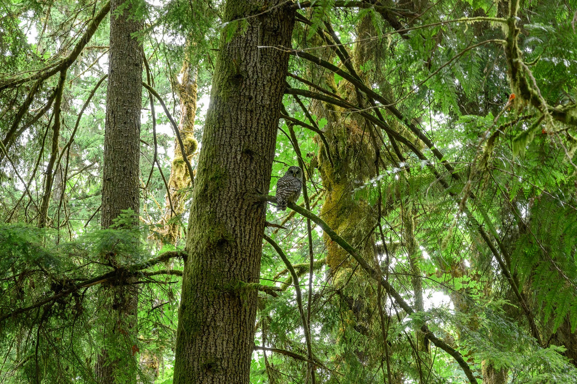
Mary Kniestedt, CLT’s Community Engagement Manager, instantly grabbed her camera. The barred owl sat and watched her impassively as her camera went click, click, click, click.

“It’s moments like this that show why our work matters,” she says. “So animals like that always have a healthy place to live.”

Why This Land Matters

On its own, the Jorgenson Conservation Easement might have seemed small to be a priority. But its location—tucked between two already conserved sites—makes it a critical puzzle piece. Connected forests give owls, bears, and other wildlife the room they need to move safely. Linked wetlands improve water quality. Together, these connections create stronger, more resilient ecosystems.

“Connecting lands allows for increased conservation benefits for both wildlife and our communities,” says CLT Executive Director Dave Winter.

Neighbors Working Together

Sometimes, conserving land happens when local property owners are passionate about preserving and protecting their land. In this case, the parcel to the south of the Jorgenson Conservation Easement had been donated to CLT in 1990 by Jack Davis. 31 years later, Vince Cottone worked with CLT to establish a conservation easement on the parcel he owned to the north. Vince talked with his neighbor Walt Jorgenson about placing his land into a conservation easement too.

“We never really own any part of the earth,” Walt says. “We are only temporary caretakers, and while I didn’t make my trees, I can help ensure the forests remain intact for the wildlife and people who come after us.”

Together, the three conserved properties now permanently preserve a larger, continuous tract of beautiful forest that contributes to maintaining our area’s unique Pacific Northwest aesthetic. And it provides important habitat for wildlife in perpetuity.


A Forest Full of Life

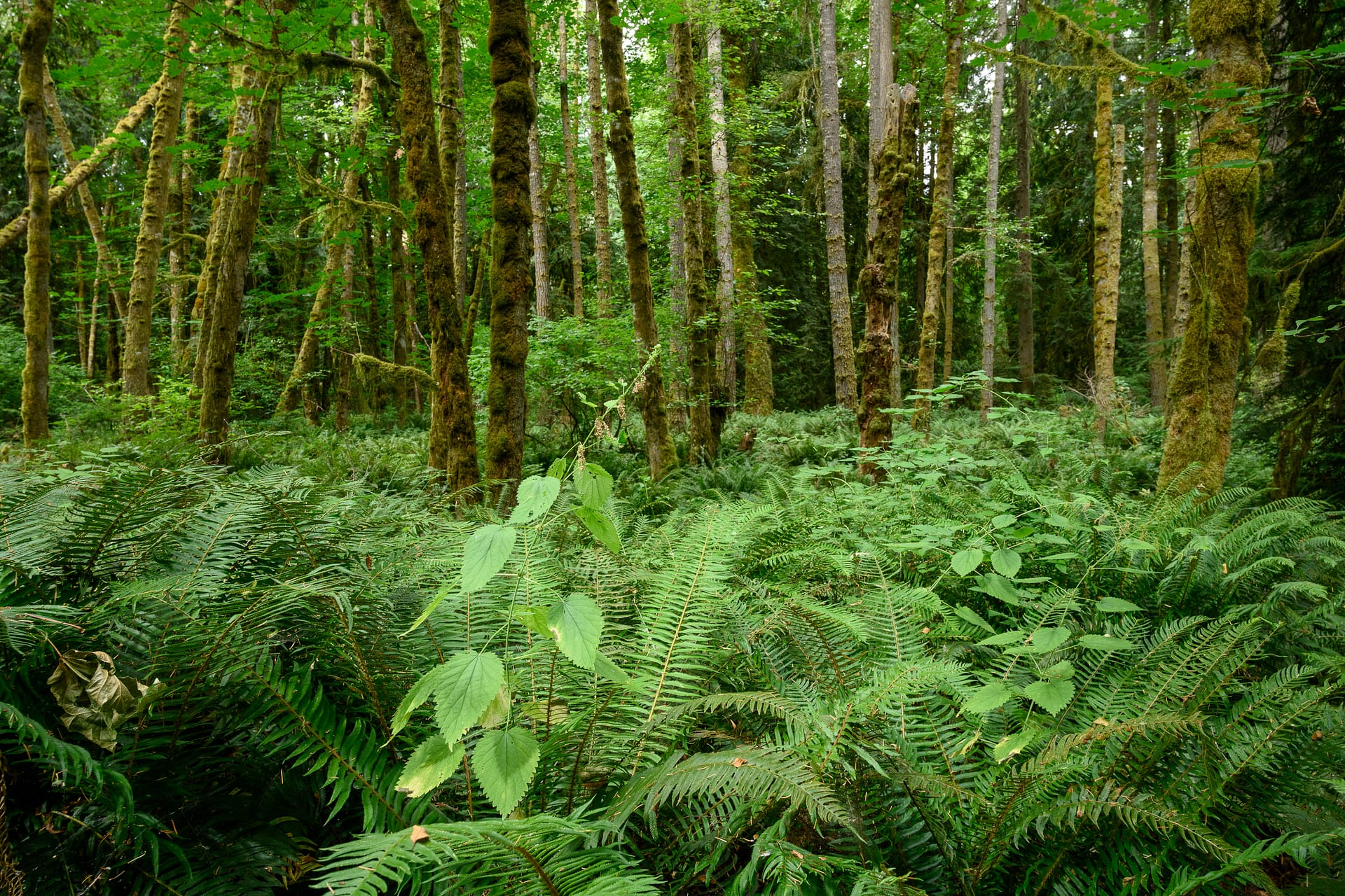
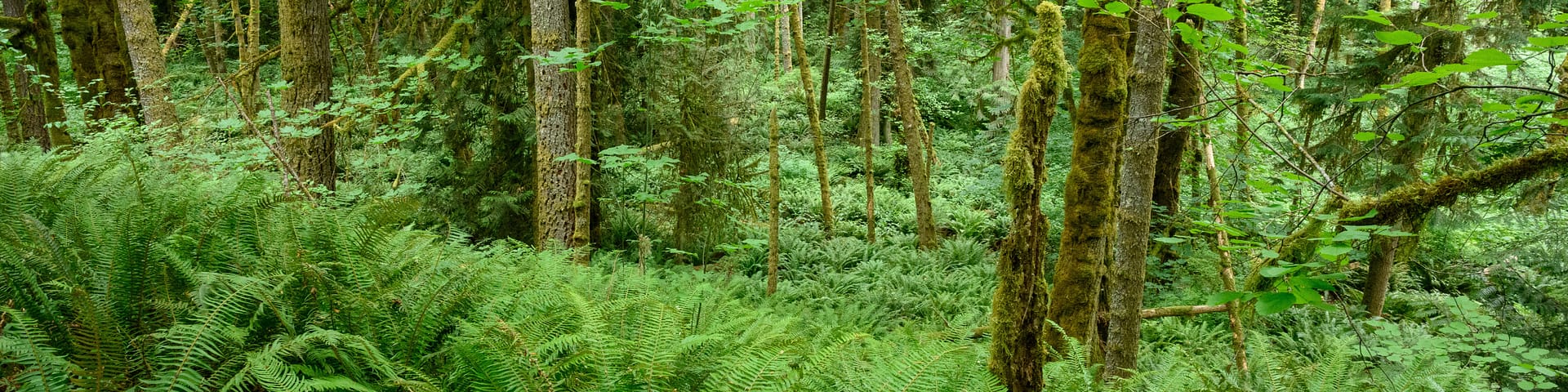
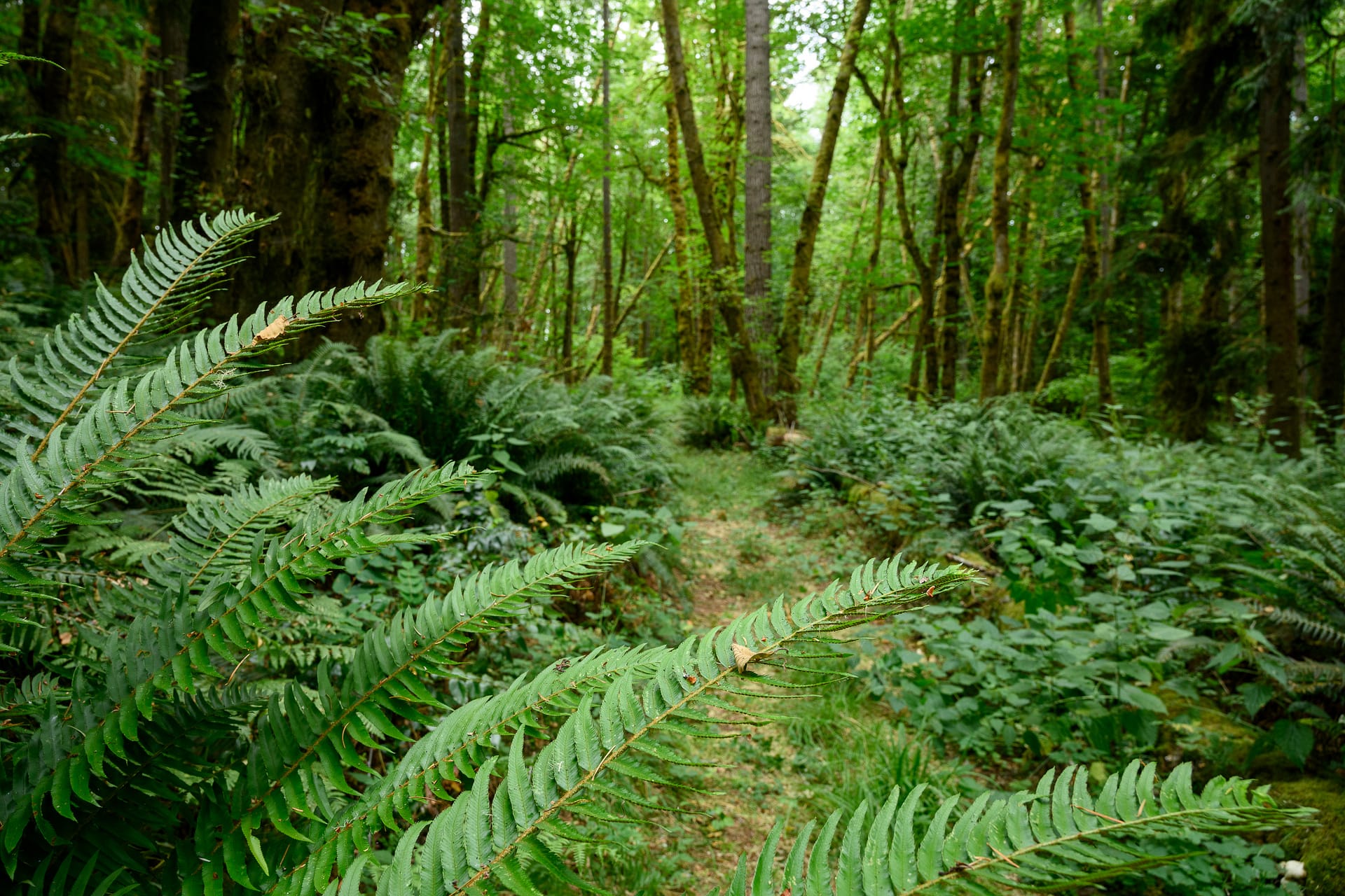
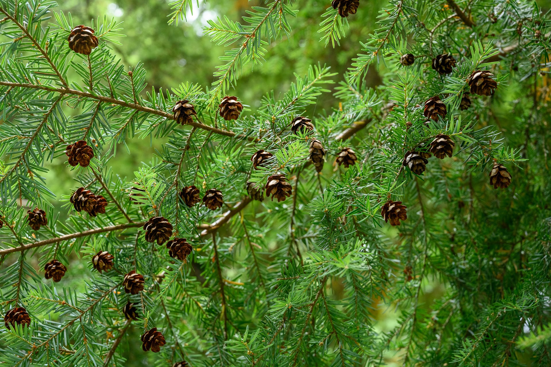
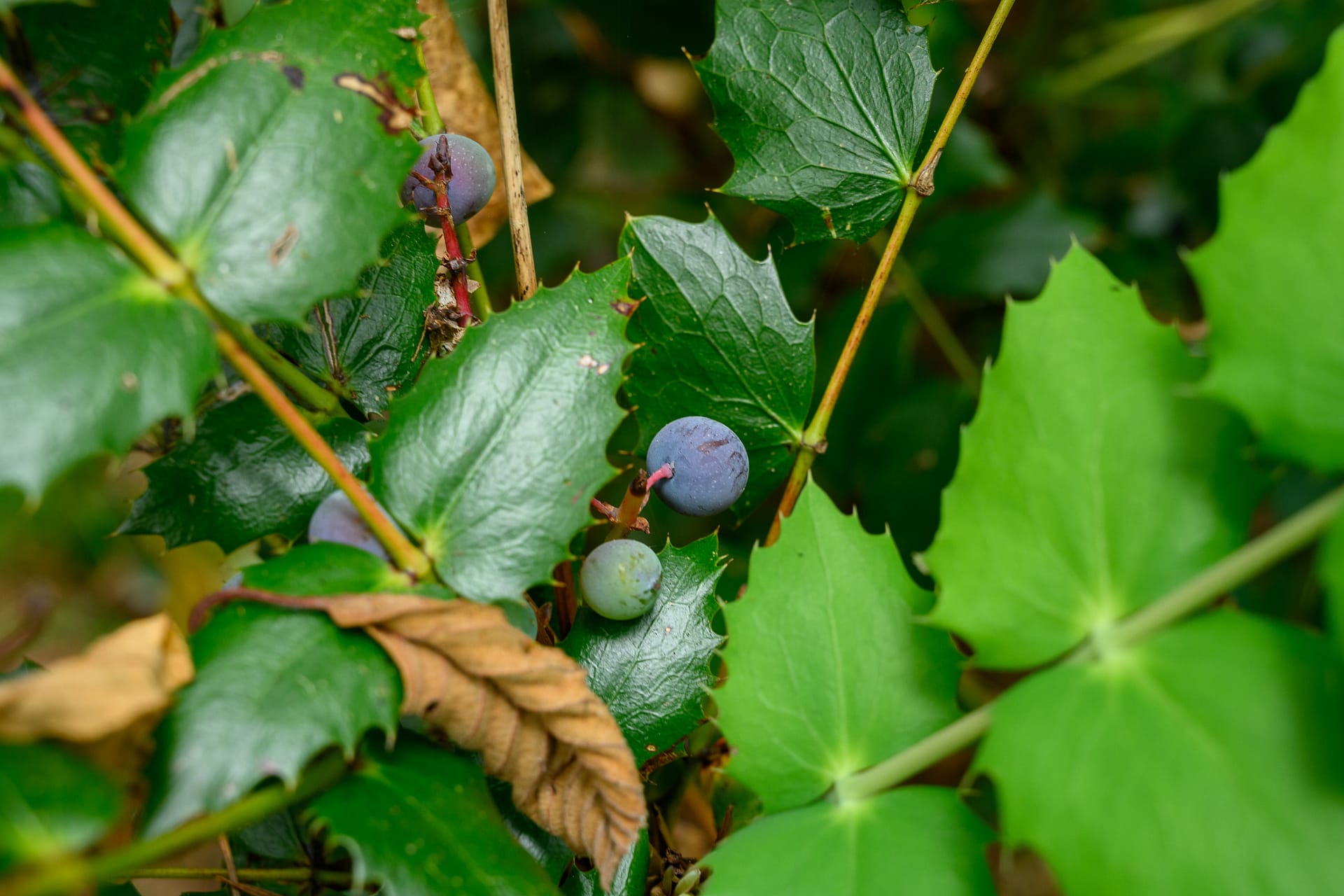
Beyond its role as a connector, The Jorgenson Conservation Easement brims with life. Towering Douglas fir, western redcedar, and big leaf maple anchor the canopy. Red huckleberry, sala, and Oregon grape fill the understory, while western skunk cabbage and false lily-of-the-valley thrive in moist soils.


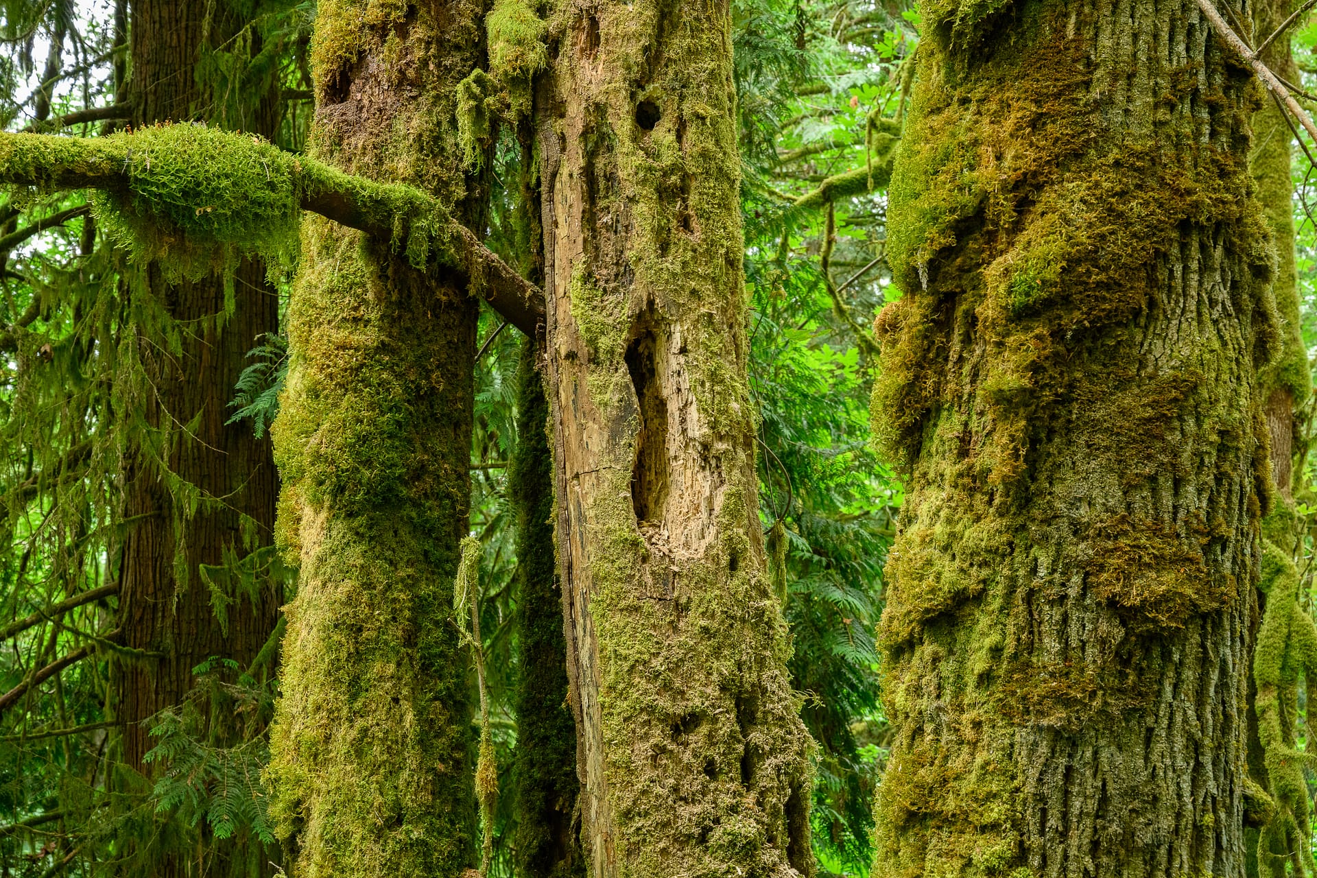
Dead trees, called snags, are also an important part of this forest. While they may look lifeless, snags provide critical habitat—nesting cavities for owls and woodpeckers, perches for raptors, and food sources for insects that in turn support a wide web of wildlife. In healthy forests like this one, living and dead trees together create the complex structure that wildlife depend on.


Other wildlife moving through the property include beaver, bobcat, Douglas squirrels, porcupines, black bear, pygmy owls, and more.

Hopkins Ditch runs through the property for 450 feet, connecting to Salmon Creek—a known coho salmon stream—and then on to the Black and Chehalis rivers, eventually spilling into the Pacific Ocean. Lush vegetation borders Hopkins Ditch as it flows through the property.

The Bigger Picture

The Jorgenson Conservation Easement shows how individual actions add up to something much larger. Each parcel conserved is valuable on its own, but when linked together their impact multiplies. Forest-dwelling species like owls and black bears need room to roam. Wetlands and waterways work best when they are a part of a network.

By strategically conserving land across the Black River Watershed, CLT and local landowners are building resilient, connected landscapes that both people and wildlife can depend on.

“Our goal is to be strategic—conserving the lands that will benefit wildlife, our communities, and the Earth’s systems the most,” says Laurence Reeves, Senior Land Projects Manager. “That way we can ensure our area remains a vibrant and flourishing ecosystem for all who live here and call this magical place home.”


Want to protect more special places like this? Donate today!

  • Facebook
  • Instragram
  • Youtube

  • PO Box 14065
  • Tumwater, WA 98511
  • Telephone: (360) 943-3012
  • Email:

  • Who We Are
  • Our Mission
  • Board & Staff
  • Collaboration
  • Financials
  • Library
  • Careers
  • Get Involved
  • Trail Steward
  • Stewardship Work Parties
  • Salmon Docent
  • K-12 Outdoor Programs
  • Ways To Give
  • Cash
  • Other Ways to Give
  • Become a Business Partner
  • Gifts of Land
  • Bequests, Estate Plans & Wills
  • Stocks, Donor Advised Funds, IRAs
  • Conserved Lands
  • Conservation Map
  • Conserving Key Habitats
  • Conservation Areas
  • Conserve Your Land
  • Visit A Preserve
  • Inspiring Kids Preserve
  • Managing Our Preserves
  • Donate
  • Contact
  • Events
  • News

Copyright © Capitol Land Trust All Rights Reserved. | Made by SlowClouds